San Vicente night lights from space
Night Light of San Vicente (Central Luzon) from space (Philippines) Src. Average luminocity for 10x10km area is 1.4711% and for 50x50km: 10.2711%.
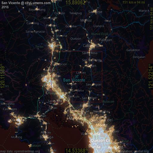
Analysis of San Vicente night lights 2016
Square area 10x10 km:
 0%
0%90-99
0%80-89
0.21%70-79
0.21%60-69
0.83%50-59
0%40-49
0.21%30-39
0.21%20-29
0.41%10-19
0.41%0-9
97.52%Square area 50x50 km:
0.45%90-99
0.58%80-89
0.65%70-79
2.33%60-69
2.76%50-59
1.09%40-49
2.38%30-39
2.58%20-29
3.66%10-19
5.94%0-9
77.56%Clear (daylight) street map image can be seen on geolist.org.
Map coordinates:
15° 53' 26.2" North, 120° 6' 57.2" East
15° 12' 47.7" North, 120° 49' 8.4" East
14° 32' 1.2" North, 121° 31' 19.7" East
Some cities around San Vicente sort by population:
• Arayat
8.8 km =5.5 mi,  217°
217°
• Cabiao
5.5 km =3.4 mi,  44°
44°
• Candaba
13.1 km =8.1 mi,  176°
176°
• Papaya
12 km =7.5 mi,  8°
8°
• San Antonio
11.1 km =6.9 mi,  21°
21°
• Pulo
12.3 km =7.6 mi,  72°
72°
• Santo Cristo
12 km =7.5 mi, 39°
• Entablado
9.4 km =5.8 mi,  30°
30°
1687410 (p: 6,835)
Sources (retrieved 2019-11-25):
» Earth at Night: Flat Maps 2012, 2016