Pakil night lights from space
Night Light of Pakil (Calabarzon) from space (Philippines) Src. Average luminocity for 10x10km area is 6.1169% and for 50x50km: 3.2356%.
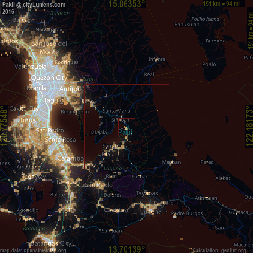
Analysis of Pakil night lights 2016
Square area 10x10 km:
 0%
0%90-99
0%80-89
0%70-79
1.95%60-69
1.52%50-59
1.73%40-49
1.52%30-39
1.52%20-29
1.52%10-19
0%0-9
90.26%Square area 50x50 km:
0%90-99
0.03%80-89
0.08%70-79
0.82%60-69
0.73%50-59
0.49%40-49
0.78%30-39
0.99%20-29
0.65%10-19
1.77%0-9
93.66%Clear (daylight) street map image can be seen on geolist.org.
Map coordinates:
15° 3' 48.7" North, 120° 46' 31.7" East
14° 23' 0.6" North, 121° 28' 43" East
13° 42' 5" North, 122° 10' 54.2" East
Some cities around Pakil sort by population:
• Santa Cruz
13.2 km =8.2 mi,  210°
210°
• Lumbang
9.8 km =6.1 mi,  191°
191°
• Paete
2.1 km =1.3 mi,  167°
167°
• Pangil
2.6 km =1.6 mi,  326°
326°
• Mabitac
7.1 km =4.4 mi,  311°
311°
• Kalayaan
10.2 km =6.3 mi,  111°
111°
• Maulawin
13.9 km =8.6 mi,  200°
200°
• Santa Maria
11.2 km =7 mi, 331°
1696395 (p: 10,693)
Sources (retrieved 2019-11-25):
» Earth at Night: Flat Maps 2012, 2016