Paete night lights from space
Night Light of Paete (Calabarzon) from space (Philippines) Src. Average luminocity for 10x10km area is 6.7316% and for 50x50km: 3.2681%.
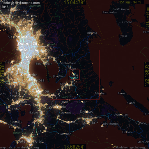

Analysis of Paete night lights 2016
Square area 10x10 km:
 0%
0%90-99
0%80-89
0%70-79
2.16%60-69
2.16%50-59
0.87%40-49
1.73%30-39
1.95%20-29
1.08%10-19
0%0-9
90.04%Square area 50x50 km:
0%90-99
0.03%80-89
0.08%70-79
0.81%60-69
0.74%50-59
0.51%40-49
0.79%30-39
1.03%20-29
0.65%10-19
1.65%0-9
93.72%Clear (daylight) street map image can be seen on geolist.org.
Map coordinates:
15° 2' 41.2" North, 120° 46' 47.2" East
14° 21' 52.9" North, 121° 28' 58.4" East
13° 40' 57.1" North, 122° 11' 9.7" East
Some cities around Paete sort by population:
• Santa Cruz
11.7 km =7.3 mi,  217°
217°
• Lumbang
7.9 km =4.9 mi,  198°
198°
• Pangil
4.7 km =2.9 mi,  335°
335°
• Mabitac
8.9 km =5.5 mi,  319°
319°
• Pakil
2.1 km =1.3 mi,  347°
347°
• Kalayaan
9.2 km =5.7 mi,  100°
100°
• Maulawin
12.1 km =7.5 mi,  206°
206°
• Santa Maria
13.3 km =8.3 mi,  333°
333°
1696718 (p: 26,855)
Sources (retrieved 2019-11-25):
» Earth at Night: Flat Maps 2012, 2016