Santa Maria night lights from space
Night Light of Santa Maria (Calabarzon) from space (Philippines) Src. Average luminocity for 10x10km area is 2.5195% and for 50x50km: 4.1115%.
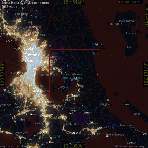
Analysis of Santa Maria night lights 2016
Square area 10x10 km:
 0%
0%90-99
0%80-89
0%70-79
0.87%60-69
0%50-59
0.22%40-49
1.52%30-39
1.73%20-29
0.87%10-19
0%0-9
94.81%Square area 50x50 km:
0.02%90-99
0.05%80-89
0.15%70-79
0.96%60-69
0.98%50-59
0.63%40-49
1.01%30-39
1.53%20-29
1.15%10-19
2.73%0-9
90.8%Clear (daylight) street map image can be seen on geolist.org.
Map coordinates:
15° 9' 6" North, 120° 43' 31.7" East
14° 28' 18.8" North, 121° 25' 43" East
13° 47' 24.2" North, 122° 7' 54.2" East
Some cities around Santa Maria sort by population:
• Pililla
13.3 km =8.3 mi,  276°
276°
• Paete
13.3 km =8.3 mi,  153°
153°
• Sampaloc
10.6 km =6.6 mi,  315°
315°
• Pangil
8.6 km =5.3 mi, 152°
• Mabitac
5.1 km =3.2 mi,  179°
179°
• Malaya
12.8 km =8 mi,  229°
229°
• Quisao
11 km =6.8 mi,  247°
247°
• Pakil
11.2 km =7 mi, 151°
1688044 (p: 6,603)
Sources (retrieved 2019-11-25):
» Earth at Night: Flat Maps 2012, 2016