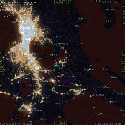
Maulawin night lights from space
Night Light of Maulawin (Calabarzon) from space (Philippines) Src. Average luminocity for 10x10km area is 22.4199% and for 50x50km: 5.592%.
Analysis of Maulawin night lights 2016
Square area 10x10 km:
 0%
0%90-99
0.65%80-89
1.52%70-79
9.09%60-69
4.98%50-59
2.81%40-49
3.46%30-39
3.46%20-29
3.25%10-19
17.75%0-9
53.03%Square area 50x50 km:
0.03%90-99
0.07%80-89
0.33%70-79
1.3%60-69
1.35%50-59
0.86%40-49
1.09%30-39
1.56%20-29
0.96%10-19
4.72%0-9
87.73%Clear (daylight) street map image can be seen on geolist.org.
Map coordinates:
14° 56' 49.4" North, 120° 43' 48.8" East
14° 16' 0" North, 121° 25' 60" East
13° 35' 3.2" North, 122° 8' 11.3" East
Some cities around Maulawin sort by population:
• Santa Cruz
2.5 km =1.6 mi,  311°
311°
• Pila
8.3 km =5.2 mi,  242°
242°
• Lumbang
4.4 km =2.7 mi,  39°
39°
• Paete
12.1 km =7.5 mi,  26°
26°
• Victoria
12 km =7.5 mi,  248°
248°
• Majayjay
14 km =8.7 mi,  162°
162°
• Pakil
13.9 km =8.6 mi,  20°
20°
• Cavinti
8.4 km =5.2 mi,  106°
106°
1700148 (p: 6,822)
Sources (retrieved 2019-11-25):
» Earth at Night: Flat Maps 2012, 2016