Masaya night lights from space
Night Light of Masaya (Calabarzon) from space (Philippines) Src. Average luminocity for 10x10km area is 19.6147% and for 50x50km: 19.9481%.
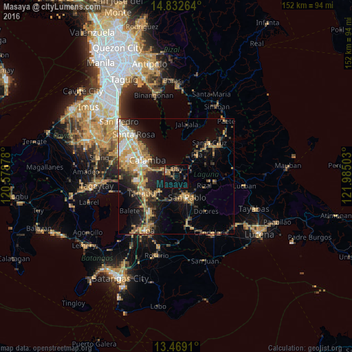
Analysis of Masaya night lights 2016
Square area 10x10 km:
 0.65%
0.65%90-99
0.22%80-89
0.87%70-79
2.81%60-69
6.28%50-59
3.25%40-49
4.76%30-39
5.63%20-29
3.25%10-19
11.69%0-9
60.61%Square area 50x50 km:
1.76%90-99
2.53%80-89
1.99%70-79
5.77%60-69
3.57%50-59
1.88%40-49
2.7%30-39
3.34%20-29
5.17%10-19
10.19%0-9
61.11%Clear (daylight) street map image can be seen on geolist.org.
Map coordinates:
14° 49' 57.5" North, 120° 34' 43.6" East
14° 9' 6.8" North, 121° 16' 54.8" East
13° 28' 8.8" North, 121° 59' 6.1" East
Some cities around Masaya sort by population:
• San Pablo
10.4 km =6.5 mi,  153°
153°
• Los Baños
4.8 km =3 mi,  295°
295°
• Calauan
3.6 km =2.2 mi,  93°
93°
• Bay
3.6 km =2.2 mi,  6°
6°
• Alaminos
10.5 km =6.5 mi,  201°
201°
• Victoria
9.9 km =6.2 mi,  31°
31°
• Bitin
7.6 km =4.7 mi,  238°
238°
• Dayap
6.4 km =4 mi,  60°
60°
1700724 (p: 7,587)
Sources (retrieved 2019-11-25):
» Earth at Night: Flat Maps 2012, 2016