Licab night lights from space
Night Light of Licab (Central Luzon) from space (Philippines) Src. Average luminocity for 10x10km area is 0.0216% and for 50x50km: 7.0552%.
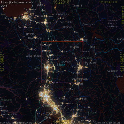
Analysis of Licab night lights 2016
Square area 10x10 km:
 0%
0%90-99
0%80-89
0%70-79
0%60-69
0%50-59
0%40-49
0%30-39
0%20-29
0%10-19
0%0-9
100%Square area 50x50 km:
0.06%90-99
0.27%80-89
0.6%70-79
1.68%60-69
1.55%50-59
0.86%40-49
1.52%30-39
1.87%20-29
1.88%10-19
5.21%0-9
84.51%Clear (daylight) street map image can be seen on geolist.org.
Map coordinates:
16° 13' 12.6" North, 120° 3' 37" East
15° 32' 38" North, 120° 45' 48.2" East
14° 51' 55.4" North, 121° 27' 59.5" East
Some cities around Licab sort by population:
• Aliaga
9.8 km =6.1 mi,  119°
119°
• Guimba
13 km =8.1 mi,  2°
2°
• La Paz
12 km =7.5 mi,  198°
198°
• Quezon
5.6 km =3.5 mi,  81°
81°
• San Nicolas
10.3 km =6.4 mi,  295°
295°
• Bibiclat
10.9 km =6.8 mi,  103°
103°
• San Manuel
12.1 km =7.5 mi,  240°
240°
• Balingcanaway
10.8 km =6.7 mi,  230°
230°
1706532 (p: 6,783)
Sources (retrieved 2019-11-25):
» Earth at Night: Flat Maps 2012, 2016