La Paz night lights from space
Night Light of La Paz (Central Luzon) from space (Philippines) Src. Average luminocity for 10x10km area is 1.9827% and for 50x50km: 8.2475%.
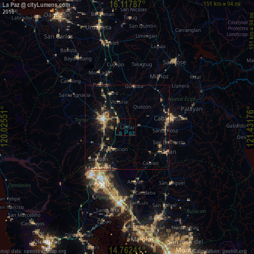

Analysis of La Paz night lights 2016
Square area 10x10 km:
 0%
0%90-99
0%80-89
0%70-79
0.43%60-69
0.43%50-59
0%40-49
1.08%30-39
0%20-29
0%10-19
0.43%0-9
97.62%Square area 50x50 km:
0.08%90-99
0.25%80-89
0.61%70-79
1.83%60-69
1.97%50-59
1.06%40-49
1.94%30-39
1.94%20-29
2.43%10-19
6.92%0-9
80.97%Clear (daylight) street map image can be seen on geolist.org.
Map coordinates:
16° 7' 4.3" North, 120° 1' 31.8" East
15° 26' 28.5" North, 120° 43' 43.1" East
14° 45' 44.7" North, 121° 25' 54.3" East
Some cities around La Paz sort by population:
• Aliaga
13.9 km =8.6 mi,  61°
61°
• Licab
12 km =7.5 mi,  18°
18°
• Santa Barbara
9.6 km =6 mi,  130°
130°
• San Manuel
8.7 km =5.4 mi,  308°
308°
• Balingcanaway
6.5 km =4 mi, 314°
• Santa Monica
9.3 km =5.8 mi,  185°
185°
• Mapalacsiao
8.3 km =5.2 mi,  259°
259°
• Murcia
13.5 km =8.4 mi,  252°
252°
1707324 (p: 25,801)
Sources (retrieved 2019-11-25):
» Earth at Night: Flat Maps 2012, 2016