San Manuel night lights from space
Night Light of San Manuel (Central Luzon) from space (Philippines) Src. Average luminocity for 10x10km area is 20.6082% and for 50x50km: 5.7129%.
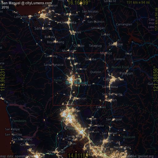
Analysis of San Manuel night lights 2016
Square area 10x10 km:
 0%
0%90-99
0%80-89
1.73%70-79
4.55%60-69
5.41%50-59
2.81%40-49
4.11%30-39
2.81%20-29
10.82%10-19
26.84%0-9
40.91%Square area 50x50 km:
0.06%90-99
0.23%80-89
0.41%70-79
1.18%60-69
1.19%50-59
0.82%40-49
1.26%30-39
1.58%20-29
1.64%10-19
4.46%0-9
87.18%Clear (daylight) street map image can be seen on geolist.org.
Map coordinates:
16° 10' 1.2" North, 119° 57' 44.3" East
15° 29' 25.9" North, 120° 39' 55.5" East
14° 48' 42.7" North, 121° 22' 6.8" East
Some cities around San Manuel sort by population:
• Tarlac City
7.3 km =4.5 mi,  260°
260°
• La Paz
8.7 km =5.4 mi,  128°
128°
• San Nicolas
10.5 km =6.5 mi,  6°
6°
• Cut-cut Primero
8.6 km =5.3 mi, 264°
• Licab
12.1 km =7.5 mi,  60°
60°
• Balingcanaway
2.3 km =1.4 mi,  113°
113°
• Mapalacsiao
7.1 km =4.4 mi,  191°
191°
• Murcia
11.3 km =7 mi,  212°
212°
1689111 (p: 5,995)
Sources (retrieved 2019-11-25):
» Earth at Night: Flat Maps 2012, 2016