Bibiclat night lights from space
Night Light of Bibiclat (Central Luzon) from space (Philippines) Src. Average luminocity for 10x10km area is 0.987% and for 50x50km: 4.3787%.
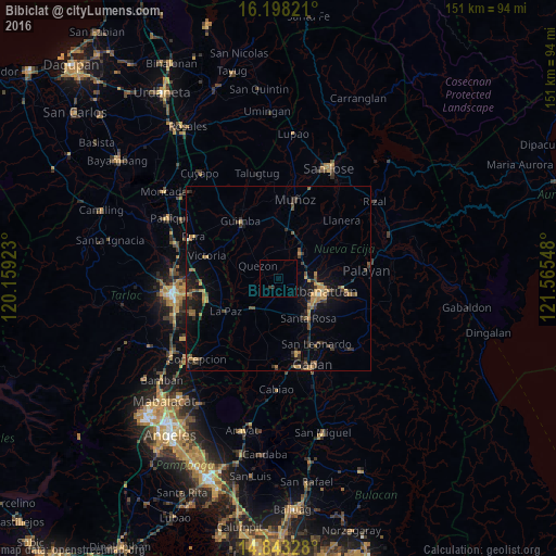
Analysis of Bibiclat night lights 2016
Square area 10x10 km:
 0%
0%90-99
0%80-89
0%70-79
0%60-69
0%50-59
0%40-49
0%30-39
0.87%20-29
0.87%10-19
0%0-9
98.27%Square area 50x50 km:
0%90-99
0.07%80-89
0.29%70-79
0.98%60-69
0.85%50-59
0.58%40-49
1.25%30-39
1.02%20-29
1.15%10-19
3.58%0-9
90.22%Clear (daylight) street map image can be seen on geolist.org.
Map coordinates:
16° 11' 53.6" North, 120° 9' 33.2" East
15° 31' 18.7" North, 120° 51' 44.5" East
14° 50' 35.8" North, 121° 33' 55.7" East
Some cities around Bibiclat sort by population:
• Cabanatuan City
11.9 km =7.4 mi,  109°
109°
• Talavera
9.6 km =6 mi,  39°
39°
• Aliaga
3.2 km =2 mi,  220°
220°
• Quezon
6.1 km =3.8 mi,  302°
302°
• Santa Rosa
13.6 km =8.5 mi,  143°
143°
• Rajal Norte
8.6 km =5.3 mi,  179°
179°
• Licab
10.9 km =6.8 mi,  283°
283°
• Santo Rosario
10.2 km =6.3 mi,  163°
163°
1725435 (p: 7,039)
Sources (retrieved 2019-11-25):
» Earth at Night: Flat Maps 2012, 2016