Quezon night lights from space
Night Light of Quezon (Central Luzon) from space (Philippines) Src. Average luminocity for 10x10km area is 0.0303% and for 50x50km: 6.2727%.
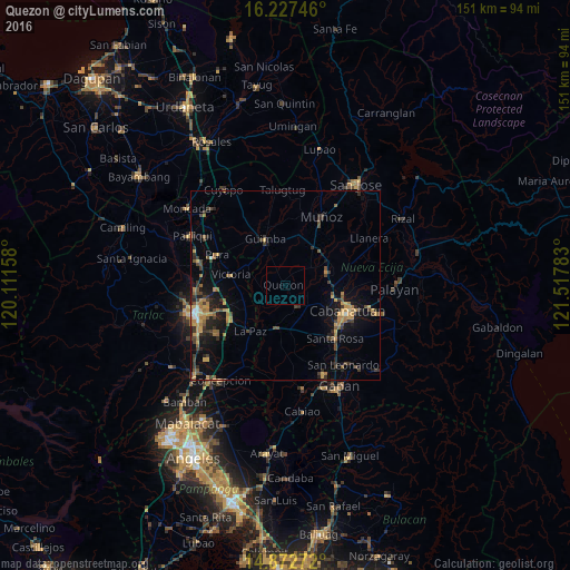
Analysis of Quezon night lights 2016
Square area 10x10 km:
 0%
0%90-99
0%80-89
0%70-79
0%60-69
0%50-59
0%40-49
0%30-39
0%20-29
0%10-19
0%0-9
100%Square area 50x50 km:
0.06%90-99
0.27%80-89
0.53%70-79
1.54%60-69
1.27%50-59
0.78%40-49
1.45%30-39
1.66%20-29
1.64%10-19
4.27%0-9
86.53%Clear (daylight) street map image can be seen on geolist.org.
Map coordinates:
16° 13' 38.9" North, 120° 6' 41.7" East
15° 33' 4.3" North, 120° 48' 52.9" East
14° 52' 21.8" North, 121° 31' 4.2" East
Some cities around Quezon sort by population:
• Talavera
11.9 km =7.4 mi,  69°
69°
• Aliaga
6.4 km =4 mi,  151°
151°
• Guimba
13.1 km =8.1 mi,  337°
337°
• Baloc
12.7 km =7.9 mi,  36°
36°
• Rajal Norte
12.9 km =8 mi,  156°
156°
• Bibiclat
6.1 km =3.8 mi,  122°
122°
• Licab
5.6 km =3.5 mi,  261°
261°
• Santo Rosario
11.5 km =7.1 mi,  25°
25°
1692199 (p: 18,451)
Sources (retrieved 2019-11-25):
» Earth at Night: Flat Maps 2012, 2016