Jalajala night lights from space
Night Light of Jalajala (Calabarzon) from space (Philippines) Src. Average luminocity for 10x10km area is 0.6905% and for 50x50km: 14.5938%.
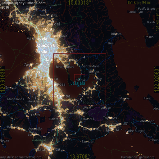
Analysis of Jalajala night lights 2016
Square area 10x10 km:
 0%
0%90-99
0%80-89
0%70-79
0%60-69
0%50-59
0%40-49
0.87%30-39
0%20-29
0.87%10-19
0%0-9
98.27%Square area 50x50 km:
1.21%90-99
1.85%80-89
1.42%70-79
3.95%60-69
2.91%50-59
1.67%40-49
1.99%30-39
2.71%20-29
3.7%10-19
6.7%0-9
71.89%Clear (daylight) street map image can be seen on geolist.org.
Map coordinates:
15° 1' 59.3" North, 120° 37' 9.8" East
14° 21' 10.8" North, 121° 19' 21" East
13° 40' 14.9" North, 122° 1' 32.3" East
Some cities around Jalajala sort by population:
• Santa Cruz
12.8 km =8 mi,  128°
128°
• Pila
14.2 km =8.8 mi,  161°
161°
• Pililla
14.8 km =9.2 mi,  353°
353°
• Victoria
14 km =8.7 mi,  177°
177°
• Mabitac
14 km =8.7 mi,  54°
54°
• Malaya
5.2 km =3.2 mi,  19°
19°
• Quisao
9.2 km =5.7 mi,  8°
8°
• Gulod
11.3 km =7 mi,  265°
265°
1710357 (p: 16,400)
Sources (retrieved 2019-11-25):
» Earth at Night: Flat Maps 2012, 2016