Malaya night lights from space
Night Light of Malaya (Calabarzon) from space (Philippines) Src. Average luminocity for 10x10km area is 1.3312% and for 50x50km: 13.3606%.
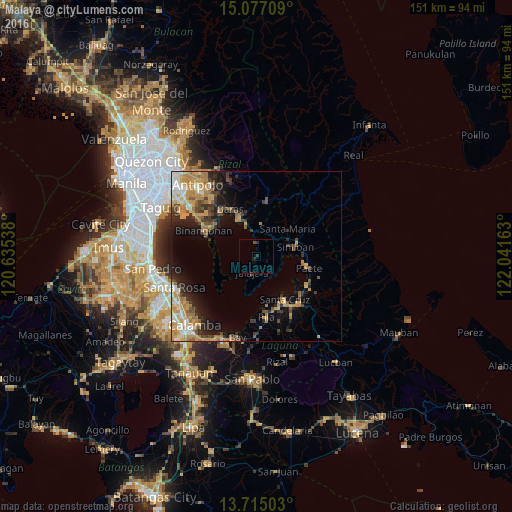
Analysis of Malaya night lights 2016
Square area 10x10 km:
 0%
0%90-99
0%80-89
0%70-79
0%60-69
0%50-59
0%40-49
0.43%30-39
1.52%20-29
1.52%10-19
0%0-9
96.54%Square area 50x50 km:
1.09%90-99
1.85%80-89
1.38%70-79
3.78%60-69
2.81%50-59
1.33%40-49
1.59%30-39
2.35%20-29
3.04%10-19
5.61%0-9
75.18%Clear (daylight) street map image can be seen on geolist.org.
Map coordinates:
15° 4' 37.5" North, 120° 38' 7.4" East
14° 23' 49.6" North, 121° 20' 18.6" East
13° 42' 54.1" North, 122° 2' 29.9" East
Some cities around Malaya sort by population:
• Tanay
12.5 km =7.8 mi,  332°
332°
• Pililla
10.4 km =6.5 mi,  340°
340°
• Pangil
13.6 km =8.5 mi,  87°
87°
• Jalajala
5.2 km =3.2 mi,  199°
199°
• Mabitac
10.3 km =6.4 mi,  71°
71°
• Quisao
4.2 km =2.6 mi,  353°
353°
• Santa Maria
12.8 km =8 mi,  49°
49°
• Gulod
14.2 km =8.8 mi,  245°
245°
1702949 (p: 11,442)
Sources (retrieved 2019-11-25):
» Earth at Night: Flat Maps 2012, 2016