Culianin night lights from space
Night Light of Culianin (Central Luzon) from space (Philippines) Src. Average luminocity for 10x10km area is 33.9773% and for 50x50km: 23.9497%.
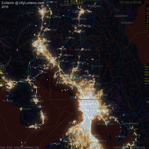
Analysis of Culianin night lights 2016
Square area 10x10 km:
 0%
0%90-99
0.41%80-89
1.45%70-79
9.3%60-69
10.54%50-59
3.93%40-49
8.68%30-39
9.5%20-29
16.12%10-19
36.78%0-9
3.31%Square area 50x50 km:
1.62%90-99
2.3%80-89
2.7%70-79
6%60-69
6.42%50-59
3.16%40-49
4.14%30-39
4.59%20-29
6.43%10-19
11.84%0-9
50.81%Clear (daylight) street map image can be seen on geolist.org.
Map coordinates:
15° 35' 36.5" North, 120° 11' 43.3" East
14° 54' 54.4" North, 120° 53' 54.5" East
14° 14' 4.6" North, 121° 36' 5.8" East
Some cities around Culianin sort by population:
• Baliuag
4.4 km =2.7 mi,  357°
357°
• Pulilan
5.5 km =3.4 mi,  254°
254°
• Guiguinto
9.2 km =5.7 mi,  190°
190°
• Plaridel
5.4 km =3.4 mi,  235°
235°
• Bustos
5.2 km =3.2 mi,  23°
23°
• Pantubig
8.4 km =5.2 mi,  45°
45°
• Pandi
8.4 km =5.2 mi,  131°
131°
• Balucuc
9.9 km =6.2 mi,  294°
294°
1716540 (p: 7,565)
Sources (retrieved 2019-11-25):
» Earth at Night: Flat Maps 2012, 2016