Balibago night lights from space
Night Light of Balibago (Central Luzon) from space (Philippines) Src. Average luminocity for 10x10km area is 70.7459% and for 50x50km: 14.1661%.
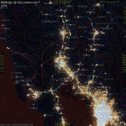
Analysis of Balibago night lights 2016
Square area 10x10 km:
 9.5%
9.5%90-99
13.02%80-89
11.57%70-79
22.31%60-69
19.42%50-59
5.17%40-49
9.71%30-39
3.31%20-29
5.58%10-19
0.41%0-9
0%Square area 50x50 km:
0.84%90-99
1.05%80-89
1.13%70-79
3.65%60-69
3.38%50-59
1.55%40-49
2.93%30-39
2.8%20-29
4.62%10-19
9.46%0-9
68.58%Clear (daylight) street map image can be seen on geolist.org.
Map coordinates:
15° 50' 23.8" North, 119° 53' 32.2" East
15° 9' 44.6" North, 120° 35' 43.4" East
14° 28' 57.6" North, 121° 17' 54.7" East
Some cities around Balibago sort by population:
• Angeles City
1.9 km =1.2 mi,  223°
223°
• Santol
3 km =1.9 mi,  269°
269°
• Mabalacat City
7.2 km =4.5 mi,  338°
338°
• Pandacaqui
6.4 km =4 mi,  80°
80°
• Telabastagan
5.1 km =3.2 mi,  164°
164°
• Manibaug Pasig
8.1 km =5 mi,  204°
204°
• Cauayan
8.3 km =5.2 mi,  98°
98°
• Calibutbut
5.3 km =3.3 mi,  176°
176°
1728196 (p: 5,057)
Sources (retrieved 2019-11-25):
» Earth at Night: Flat Maps 2012, 2016