Calibutbut night lights from space
Night Light of Calibutbut (Central Luzon) from space (Philippines) Src. Average luminocity for 10x10km area is 59.5227% and for 50x50km: 15.2527%.
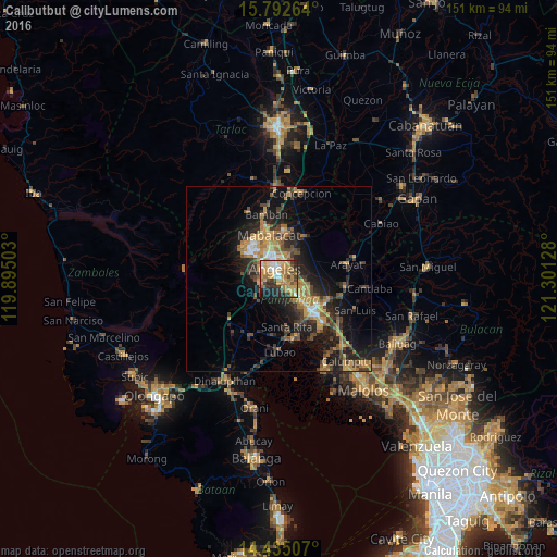
Analysis of Calibutbut night lights 2016
Square area 10x10 km:
 5.79%
5.79%90-99
7.44%80-89
8.68%70-79
18.8%60-69
20.45%50-59
3.1%40-49
9.92%30-39
5.79%20-29
11.16%10-19
8.47%0-9
0.41%Square area 50x50 km:
0.84%90-99
1.05%80-89
1.23%70-79
3.99%60-69
3.7%50-59
1.6%40-49
3.27%30-39
2.98%20-29
5.21%10-19
10.45%0-9
65.67%Clear (daylight) street map image can be seen on geolist.org.
Map coordinates:
15° 47' 33.5" North, 119° 53' 42.1" East
15° 6' 53.8" North, 120° 35' 53.3" East
14° 26' 6.3" North, 121° 18' 4.6" East
Some cities around Calibutbut sort by population:
• Angeles City
4.2 km =2.6 mi,  337°
337°
• Santol
6.2 km =3.9 mi,  327°
327°
• Bulaon
7.8 km =4.8 mi,  117°
117°
• Telabastagan
1.1 km =0.7 mi,  68°
68°
• Manibaug Pasig
4.2 km =2.6 mi,  240°
240°
• Porac
7.7 km =4.8 mi,  230°
230°
• Pulung Santol
8.6 km =5.3 mi,  206°
206°
• Balibago
5.3 km =3.3 mi,  356°
356°
1720344 (p: 5,282)
Sources (retrieved 2019-11-25):
» Earth at Night: Flat Maps 2012, 2016