Yungay night lights from space
Night Light of Yungay (Ancash) from space (Peru) Src. Average luminocity for 10x10km area is 9.6861% and for 50x50km: 2.9254%.
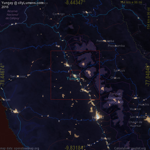
Analysis of Yungay night lights 2016
Square area 10x10 km:
100  0.43%
0.43%
90-99 0.43%
80-89 0.43%
70-79 3.9%
60-69 0.87%
50-59 1.3%
40-49 2.6%
30-39 2.6%
20-29 1.73%
10-19 0%
0-9 85.71%
0.43%90-99
0.43%80-89
0.43%70-79
3.9%60-69
0.87%50-59
1.3%40-49
2.6%30-39
2.6%20-29
1.73%10-19
0%0-9
85.71%Square area 50x50 km:
100 0.03%
90-99 0.04%
80-89 0.15%
70-79 0.45%
60-69 0.56%
50-59 1.18%
40-49 0.85%
30-39 0.7%
20-29 0.32%
10-19 0.14%
0-9 95.56%
0.03%90-99
0.04%80-89
0.15%70-79
0.45%60-69
0.56%50-59
1.18%40-49
0.85%30-39
0.7%20-29
0.32%10-19
0.14%0-9
95.56%Clear (daylight) street map image can be seen on geolist.org.
Map coordinates:
8° 26' 36.5" South, 78° 26' 48.3" West
9° 8' 18" South, 77° 44' 37" West
9° 49' 54.6" South, 77° 2' 25.8" West
Some cities around Yungay sort by population:
• Chimbote
91.8 km =57 mi,  273°
273°
• Huaraz
49.4 km =30.7 mi,  151°
151°
• Huarmey
112.7 km =70 mi,  203°
203°
• Coishco
96.6 km =60 mi,  277°
277°
• Puerto Santa
100.6 km =62.5 mi, 279°
• Carás
12.4 km =7.7 mi,  324°
324°
• Yauya
51.7 km =32.1 mi,  70°
70°
• Carhuaz
19.3 km =12 mi, 145°
3690673 (p: 5,269)
Sources (retrieved 2019-11-25):
» Earth at Night: Flat Maps 2012, 2016