Pimentel night lights from space
Night Light of Pimentel (Lambayeque) from space (Peru) Src. Average luminocity for 10x10km area is 26.974% and for 50x50km: 11.6051%.
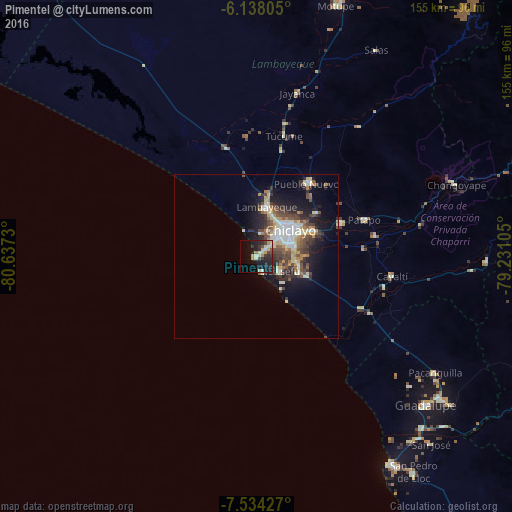
Analysis of Pimentel night lights 2016
Square area 10x10 km:
100  0.22%
0.22%
90-99 7.36%
80-89 4.98%
70-79 3.9%
60-69 1.52%
50-59 0.87%
40-49 4.11%
30-39 4.98%
20-29 11.47%
10-19 25.11%
0-9 35.5%
0.22%90-99
7.36%80-89
4.98%70-79
3.9%60-69
1.52%50-59
0.87%40-49
4.11%30-39
4.98%20-29
11.47%10-19
25.11%0-9
35.5%Square area 50x50 km:
100 1.24%
90-99 2.55%
80-89 1.55%
70-79 1.11%
60-69 1.13%
50-59 1.51%
40-49 2.33%
30-39 2.21%
20-29 3.29%
10-19 6.76%
0-9 76.32%
1.24%90-99
2.55%80-89
1.55%70-79
1.11%60-69
1.13%50-59
1.51%40-49
2.33%30-39
2.21%20-29
3.29%10-19
6.76%0-9
76.32%Clear (daylight) street map image can be seen on geolist.org.
Map coordinates:
6° 8' 17" South, 80° 38' 14.3" West
6° 50' 12" South, 79° 56' 3" West
7° 32' 3.4" South, 79° 13' 51.8" West
Some cities around Pimentel sort by population:
• Chiclayo
12.6 km =7.8 mi,  54°
54°
• Lambayeque
15.4 km =9.6 mi,  11°
11°
• Picsi
22.5 km =14 mi, 53°
• Monsefú
8.4 km =5.2 mi,  120°
120°
• Eten
11.1 km =6.9 mi,  135°
135°
• Santa Rosa
14.7 km =9.1 mi, 53°
• Reque
13.2 km =8.2 mi,  104°
104°
• San José
16.1 km =10 mi, 47°
3693584 (p: 15,552)
Sources (retrieved 2019-11-25):
» Earth at Night: Flat Maps 2012, 2016