Chota night lights from space
Night Light of Chota (Cajamarca) from space (Peru) Src. Average luminocity for 10x10km area is 7.5801% and for 50x50km: 1.516%.
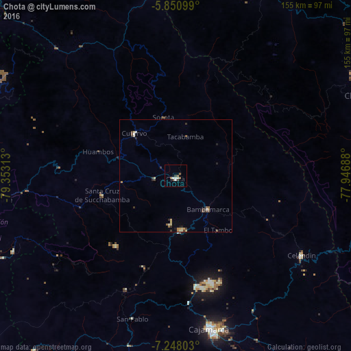
Analysis of Chota night lights 2016
Square area 10x10 km:
 1.08%
1.08%90-99
2.38%80-89
0%70-79
0%60-69
0.43%50-59
2.81%40-49
1.08%30-39
1.73%20-29
0%10-19
0.22%0-9
90.26%Square area 50x50 km:
0.09%90-99
0.29%80-89
0.22%70-79
0.16%60-69
0.16%50-59
0.26%40-49
0.26%30-39
0.46%20-29
0.22%10-19
0.12%0-9
97.75%Clear (daylight) street map image can be seen on geolist.org.
Map coordinates:
5° 51' 3.6" South, 79° 21' 11.3" West
6° 33' 0" South, 78° 39' 0" West
7° 14' 52.9" South, 77° 56' 48.8" West
Some cities around Chota sort by population:
• Cajamarca
70.2 km =43.6 mi,  166°
166°
• Bagua Grande
91.2 km =56.7 mi,  14°
14°
• Chachapoyas
93.3 km =58 mi,  67°
67°
• Chongoyape
82.3 km =51.1 mi,  262°
262°
• Celendín
65.8 km =40.9 mi,  122°
122°
• Bambamarca
19.6 km =12.2 mi,  139°
139°
• Cajaruro
93.8 km =58.3 mi,  15°
15°
• Oyotún
79 km =49.1 mi,  245°
245°
3698141 (p: 14,240)
Sources (retrieved 2019-11-25):
» Earth at Night: Flat Maps 2012, 2016