Kaiapoi night lights from space
Night Light of Kaiapoi (Canterbury) from space (New Zealand) Src. Average luminocity for 10x10km area is 16.1905% and for 50x50km: 10.9257%.
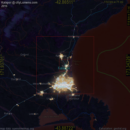
Analysis of Kaiapoi night lights 2016
Square area 10x10 km:
 0%
0%90-99
3.97%80-89
1.43%70-79
0.79%60-69
1.75%50-59
1.9%40-49
1.75%30-39
2.86%20-29
2.86%10-19
16.35%0-9
66.35%Square area 50x50 km:
1.31%90-99
2.7%80-89
1.71%70-79
2.06%60-69
1%50-59
1%40-49
0.99%30-39
1.73%20-29
2.7%10-19
4.12%0-9
80.69%Clear (daylight) street map image can be seen on geolist.org.
Map coordinates:
42° 51' 54.4" South, 171° 56' 13.2" East
43° 22' 42" South, 172° 38' 24.5" East
43° 53' 14" South, 173° 20' 35.7" East
Some cities around Kaiapoi sort by population:
• Christchurch
17.2 km =10.7 mi,  181°
181°
• Nelson
240.2 km =149.3 mi,  12°
12°
• Ashburton
93.3 km =58 mi,  231°
231°
• Timaru
158.6 km =98.5 mi,  224°
224°
• Blenheim
233.4 km =145 mi,  27°
27°
• Richmond
231.7 km =144 mi, 11°
• Oamaru
232.9 km =144.7 mi,  214°
214°
• Greymouth
155 km =96.3 mi,  310°
310°
6220587 (p: 10,200)
Sources (retrieved 2019-11-25):
» Earth at Night: Flat Maps 2012, 2016