Udenhout night lights from space
Night Light of Udenhout (North Brabant) from space (Netherlands) Src. Average luminocity for 10x10km area is 35.3289% and for 50x50km: 26.7683%.
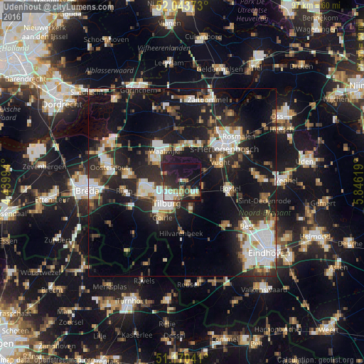
Analysis of Udenhout night lights 2016
Square area 10x10 km:
 5.61%
5.61%90-99
5.88%80-89
4.55%70-79
2.81%60-69
4.68%50-59
4.55%40-49
3.07%30-39
4.81%20-29
16.58%10-19
32.75%0-9
14.71%Square area 50x50 km:
4.95%90-99
5.47%80-89
2.34%70-79
2.44%60-69
2.33%50-59
2.95%40-49
3.17%30-39
4.18%20-29
9.56%10-19
22.66%0-9
39.96%Clear (daylight) street map image can be seen on geolist.org.
Map coordinates:
52° 2' 37.4" North, 4° 26' 23.8" East
51° 36' 33" North, 5° 8' 35" East
51° 10' 13.5" North, 5° 50' 46.3" East
Some cities around Udenhout sort by population:
• Tilburg
7 km =4.3 mi,  210°
210°
• Waalwijk
9.6 km =6 mi,  328°
328°
• Oisterwijk
4.6 km =2.9 mi,  136°
136°
• Loon op Zand
5.1 km =3.2 mi,  293°
293°
• Korvel
8.3 km =5.2 mi,  216°
216°
• Groenewoud
8.7 km =5.4 mi,  204°
204°
• Broekhoven
7.7 km =4.8 mi, 207°
• De Reit
8.4 km =5.2 mi,  230°
230°
2746003 (p: 7,650)
Sources (retrieved 2019-11-25):
» Earth at Night: Flat Maps 2012, 2016