De Reit night lights from space
Night Light of De Reit (North Brabant) from space (Netherlands) Src. Average luminocity for 10x10km area is 66.6364% and for 50x50km: 24.42%.
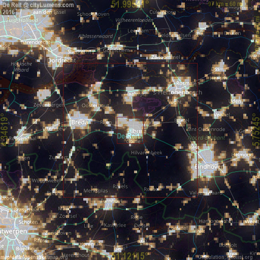
Analysis of De Reit night lights 2016
Square area 10x10 km:
 20.45%
90-99
21.39%80-89
7.22%70-79
6.68%60-69
2.41%50-59
6.42%40-49
4.81%30-39
7.09%20-29
15.51%10-19
6.82%0-9
1.2%Square area 50x50 km:
3.96%90-99
4.52%80-89
2.02%70-79
2.27%60-69
2.2%50-59
2.71%40-49
2.87%30-39
4.11%20-29
10.21%10-19
23.68%0-9
41.45%Clear (daylight) street map image can be seen on geolist.org.
Map coordinates:
51° 59' 43.5" North, 4° 20' 46.3" East
51° 33' 37.4" North, 5° 2' 57.6" East
51° 7' 16.1" North, 5° 45' 8.8" East
Some cities around De Reit sort by population:
• Tilburg
3 km =1.9 mi,  100°
100°
• Loon op Zand
7.7 km =4.8 mi,  13°
13°
• Goirle
4.6 km =2.9 mi,  164°
164°
• Korvel
1.9 km =1.2 mi,  129°
129°
• Groenewoud
3.7 km =2.3 mi, 130°
• Broekhoven
3.2 km =2 mi,  115°
115°
• Gilze
7.8 km =4.8 mi,  256°
256°
• De Blaak
1.6 km =1 mi,  191°
191°
2757108 (p: 6,105)
Sources (retrieved 2019-11-25):
» Earth at Night: Flat Maps 2012, 2016