Groenewoud night lights from space
Night Light of Groenewoud (North Brabant) from space (Netherlands) Src. Average luminocity for 10x10km area is 53.1324% and for 50x50km: 25.9536%.
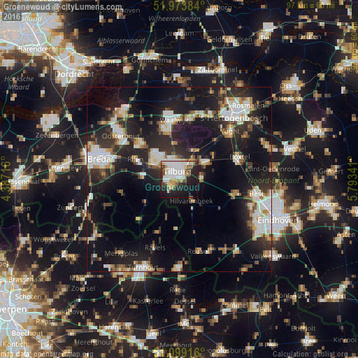
Analysis of Groenewoud night lights 2016
Square area 10x10 km:
 16.04%
90-99
13.9%80-89
4.01%70-79
6.42%60-69
2.54%50-59
5.61%40-49
4.41%30-39
4.01%20-29
16.71%10-19
22.19%0-9
4.14%Square area 50x50 km:
4.63%90-99
5.09%80-89
2.29%70-79
2.51%60-69
2.38%50-59
2.89%40-49
2.75%30-39
4.33%20-29
9.86%10-19
21.68%0-9
41.6%Clear (daylight) street map image can be seen on geolist.org.
Map coordinates:
51° 58' 25.8" North, 4° 23' 13.8" East
51° 32' 19" North, 5° 5' 25" East
51° 5' 57" North, 5° 47' 36.3" East
Some cities around Groenewoud sort by population:
• Tilburg
1.9 km =1.2 mi,  2°
2°
• Oisterwijk
8.2 km =5.1 mi,  56°
56°
• Goirle
2.6 km =1.6 mi,  219°
219°
• Korvel
1.8 km =1.1 mi,  312°
312°
• Hilvarenbeek
6.7 km =4.2 mi,  150°
150°
• Broekhoven
1.1 km =0.7 mi,  5°
5°
• De Reit
3.7 km =2.3 mi, 310°
• De Blaak
3.3 km =2.1 mi,  285°
285°
2755287 (p: 7,710)
Sources (retrieved 2019-11-25):
» Earth at Night: Flat Maps 2012, 2016