Maasbracht night lights from space
Night Light of Maasbracht (Limburg) from space (Netherlands) Src. Average luminocity for 10x10km area is 23.6618% and for 50x50km: 19.1092%.
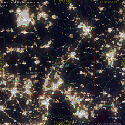
Analysis of Maasbracht night lights 2016
Square area 10x10 km:
 1.2%
1.2%90-99
0.94%80-89
2.14%70-79
4.01%60-69
3.48%50-59
5.61%40-49
4.95%30-39
3.21%20-29
4.14%10-19
43.18%0-9
27.14%Square area 50x50 km:
2.02%90-99
2.71%80-89
1.71%70-79
1.99%60-69
2.54%50-59
2.84%40-49
3.38%30-39
3.57%20-29
6.44%10-19
15.65%0-9
57.14%Clear (daylight) street map image can be seen on geolist.org.
Map coordinates:
51° 34' 42.1" North, 5° 10' 59.3" East
51° 8' 21.4" North, 5° 53' 10.6" East
50° 41' 45.7" North, 6° 35' 21.8" East
Some cities around Maasbracht sort by population:
• Sittard
15.7 km =9.8 mi,  184°
184°
• Roermond
9.3 km =5.8 mi,  49°
49°
• Heinsberg, DE
17.1 km =10.6 mi,  119°
119°
• Maaseik, BE
8.5 km =5.3 mi,  237°
237°
• Kinrooi, BE
10.1 km =6.3 mi,  273°
273°
• Haelen
11.8 km =7.3 mi,  24°
24°
• Waldfeucht, DE
10.8 km =6.7 mi,  138°
138°
• Heythuysen
12.3 km =7.6 mi,  3°
3°
2751303 (p: 5,680)
Sources (retrieved 2019-11-25):
» Earth at Night: Flat Maps 2012, 2016