Heythuysen night lights from space
Night Light of Heythuysen (Limburg) from space (Netherlands) Src. Average luminocity for 10x10km area is 8.1443% and for 50x50km: 16.7474%.
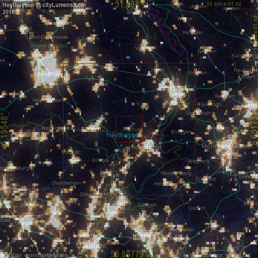
Analysis of Heythuysen night lights 2016
Square area 10x10 km:
 0%
0%90-99
0%80-89
0%70-79
0.98%60-69
2.38%50-59
1.12%40-49
2.52%30-39
1.96%20-29
3.08%10-19
6.16%0-9
81.79%Square area 50x50 km:
1.76%90-99
2.28%80-89
1.56%70-79
1.71%60-69
1.97%50-59
2.7%40-49
2.84%30-39
2.29%20-29
5%10-19
15.97%0-9
61.93%Clear (daylight) street map image can be seen on geolist.org.
Map coordinates:
51° 41' 16.8" North, 5° 11' 43.7" East
51° 15' 0" North, 5° 53' 55" East
50° 48' 28" North, 6° 36' 6.2" East
Some cities around Heythuysen sort by population:
• Roermond
8.8 km =5.5 mi,  135°
135°
• Haelen
4.4 km =2.7 mi,  111°
111°
• Nederweert
11.2 km =7 mi,  290°
290°
• Panningen
10.2 km =6.3 mi,  33°
33°
• Reuver
13 km =8.1 mi,  73°
73°
• Maasbracht
12.3 km =7.6 mi,  183°
183°
• Helden
10.4 km =6.5 mi,  42°
42°
• Meijel
10.5 km =6.5 mi,  354°
354°
2754111 (p: 6,420)
Sources (retrieved 2019-11-25):
» Earth at Night: Flat Maps 2012, 2016