Waldfeucht night lights from space
Night Light of Waldfeucht (North Rhine-Westphalia) from space (Germany) Src. Average luminocity for 10x10km area is 1.738% and for 50x50km: 22.4581%.
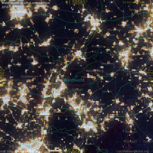
Analysis of Waldfeucht night lights 2016
Square area 10x10 km:
 0.27%
0.27%90-99
0.27%80-89
0%70-79
0%60-69
0%50-59
0%40-49
0%30-39
0.53%20-29
0%10-19
0%0-9
98.93%Square area 50x50 km:
2.74%90-99
4.05%80-89
2.17%70-79
2.46%60-69
2.69%50-59
2.94%40-49
3.57%30-39
4.23%20-29
7.68%10-19
16.04%0-9
51.42%Clear (daylight) street map image can be seen on geolist.org.
Map coordinates:
51° 30' 21.1" North, 5° 17' 6.1" East
51° 3' 58" North, 5° 59' 17.3" East
50° 37' 19.7" North, 6° 41' 28.6" East
Some cities around Waldfeucht sort by population:
• Sittard, NL
11.2 km =7 mi,  227°
227°
• Roermond, NL
14.2 km =8.8 mi,  359°
359°
• Heinsberg
7.8 km =4.8 mi,  92°
92°
• Brunssum, NL
13.3 km =8.3 mi,  185°
185°
• Geilenkirchen
14.2 km =8.8 mi,  140°
140°
• Wassenberg
12.2 km =7.6 mi,  72°
72°
• Gangelt
8.2 km =5.1 mi,  175°
175°
• Maasbracht, NL
10.8 km =6.7 mi,  318°
318°
2815035 (p: 9,305)
Sources (retrieved 2019-11-25):
» Earth at Night: Flat Maps 2012, 2016