Hilvarenbeek night lights from space
Night Light of Hilvarenbeek (North Brabant) from space (Netherlands) Src. Average luminocity for 10x10km area is 9.4184% and for 50x50km: 26.0565%.
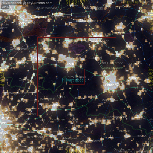
Analysis of Hilvarenbeek night lights 2016
Square area 10x10 km:
 0%
0%90-99
0.53%80-89
0%70-79
1.34%60-69
1.07%50-59
0.94%40-49
0.94%30-39
0.8%20-29
8.29%10-19
16.98%0-9
69.12%Square area 50x50 km:
4.83%90-99
5.36%80-89
2.4%70-79
2.49%60-69
2.42%50-59
2.75%40-49
2.84%30-39
4.01%20-29
9.28%10-19
19.09%0-9
44.53%Clear (daylight) street map image can be seen on geolist.org.
Map coordinates:
51° 55' 17.7" North, 4° 26' 3.8" East
51° 29' 9" North, 5° 8' 15" East
51° 2' 45.2" North, 5° 50' 26.3" East
Some cities around Hilvarenbeek sort by population:
• Tilburg
8.4 km =5.2 mi,  337°
337°
• Oisterwijk
11 km =6.8 mi,  18°
18°
• Goirle
6.3 km =3.9 mi,  308°
308°
• Korvel
8.5 km =5.3 mi,  326°
326°
• Groenewoud
6.7 km =4.2 mi, 330°
• Broekhoven
7.6 km =4.7 mi, 335°
• De Reit
10.3 km =6.4 mi,  323°
323°
• De Blaak
9.3 km =5.8 mi, 316°
2754066 (p: 7,855)
Sources (retrieved 2019-11-25):
» Earth at Night: Flat Maps 2012, 2016