De Blaak night lights from space
Night Light of De Blaak (North Brabant) from space (Netherlands) Src. Average luminocity for 10x10km area is 59.3957% and for 50x50km: 24.4843%.
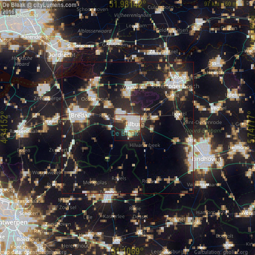
Analysis of De Blaak night lights 2016
Square area 10x10 km:
 18.32%
90-99
18.05%80-89
6.15%70-79
6.42%60-69
2.01%50-59
5.21%40-49
3.48%30-39
4.81%20-29
16.71%10-19
13.77%0-9
5.08%Square area 50x50 km:
4.04%90-99
4.56%80-89
2%70-79
2.3%60-69
2.2%50-59
2.77%40-49
2.82%30-39
4.1%20-29
10.08%10-19
23.54%0-9
41.59%Clear (daylight) street map image can be seen on geolist.org.
Map coordinates:
51° 58' 53.1" North, 4° 20' 29.5" East
51° 32' 46.5" North, 5° 2' 40.7" East
51° 6' 24.8" North, 5° 44' 52" East
Some cities around De Blaak sort by population:
• Tilburg
3.4 km =2.1 mi,  72°
72°
• Loon op Zand
9.3 km =5.8 mi,  13°
13°
• Goirle
3.2 km =2 mi,  151°
151°
• Korvel
1.8 km =1.1 mi,  78°
78°
• Groenewoud
3.3 km =2.1 mi,  105°
105°
• Broekhoven
3.3 km =2.1 mi,  86°
86°
• Gilze
7.2 km =4.5 mi,  268°
268°
• De Reit
1.6 km =1 mi, 11°
2757777 (p: 6,005)
Sources (retrieved 2019-11-25):
» Earth at Night: Flat Maps 2012, 2016