Villa El Carmen night lights from space
Night Light of Villa El Carmen (Managua) from space (Nicaragua) Src. Average luminocity for 10x10km area is 0% and for 50x50km: 5.8162%.
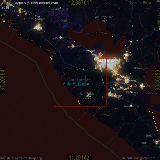
Analysis of Villa El Carmen night lights 2016
Square area 10x10 km:
 0%
0%90-99
0%80-89
0%70-79
0%60-69
0%50-59
0%40-49
0%30-39
0%20-29
0%10-19
0%0-9
100%Square area 50x50 km:
0.83%90-99
1.41%80-89
0.66%70-79
0.66%60-69
0.97%50-59
0.75%40-49
0.77%30-39
0.88%20-29
1.23%10-19
2.2%0-9
89.63%Clear (daylight) street map image can be seen on geolist.org.
Map coordinates:
12° 40' 1.2" North, 87° 12' 31.8" West
11° 58' 48.3" North, 86° 30' 20.6" West
11° 17' 29.1" North, 85° 48' 9.3" West
Some cities around Villa El Carmen sort by population:
• Managua
32.5 km =20.2 mi,  58°
58°
• Ciudad Sandino
26.5 km =16.5 mi,  41°
41°
• Diriamba
32 km =19.9 mi,  115°
115°
• San Rafael del Sur
16.4 km =10.2 mi,  153°
153°
• Nagarote
32.4 km =20.1 mi,  348°
348°
• San Marcos
33.8 km =21 mi,  103°
103°
• El Crucero
21.4 km =13.3 mi,  87°
87°
• Ticuantepe
33.1 km =20.6 mi,  81°
81°
3620473 (p: 5,219)
Sources (retrieved 2019-11-25):
» Earth at Night: Flat Maps 2012, 2016