Yahualica de González Gallo night lights from space
Night Light of Yahualica de González Gallo (Jalisco) from space (Mexico) Src. Average luminocity for 10x10km area is 8.8313% and for 50x50km: 1.9594%.
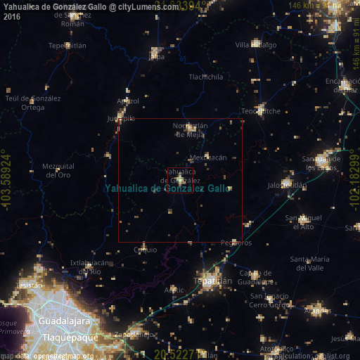
Analysis of Yahualica de González Gallo night lights 2016
Square area 10x10 km:
 0%
0%90-99
0.6%80-89
2.58%70-79
0.79%60-69
1.59%50-59
3.17%40-49
1.59%30-39
0%20-29
0.79%10-19
1.59%0-9
87.3%Square area 50x50 km:
0%90-99
0.13%80-89
0.44%70-79
0.24%60-69
0.2%50-59
0.28%40-49
0.76%30-39
0.51%20-29
0.43%10-19
0.17%0-9
96.84%Clear (daylight) street map image can be seen on geolist.org.
Map coordinates:
21° 50' 2.2" North, 103° 35' 21.3" West
21° 10' 47.2" North, 102° 53' 10" West
20° 31' 21.8" North, 102° 10' 58.8" West
Some cities around Yahualica de González Gallo sort by population:
• Tepatitlán de Morelos
42.3 km =26.3 mi,  162°
162°
• Jalostotitlán
43.8 km =27.2 mi,  91°
91°
• Teocaltiche
42.9 km =26.7 mi,  48°
48°
• Nochistlán de Mejía
20.9 km =13 mi,  11°
11°
• Capilla de Guadalupe
49.7 km =30.9 mi,  142°
142°
• Acatic
44.5 km =27.7 mi,  183°
183°
• Ixtlahuacán del Río
50.8 km =31.6 mi,  226°
226°
• Juchipila
34.9 km =21.7 mi,  316°
316°
3979982 (p: 13,655)
Sources (retrieved 2019-11-25):
» Earth at Night: Flat Maps 2012, 2016