Acatic night lights from space
Night Light of Acatic (Jalisco) from space (Mexico) Src. Average luminocity for 10x10km area is 7.9527% and for 50x50km: 8.8118%.
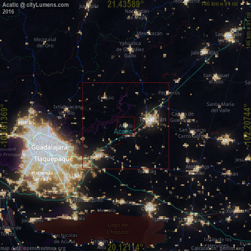
Analysis of Acatic night lights 2016
Square area 10x10 km:
 0%
0%90-99
0.38%80-89
1.7%70-79
1.52%60-69
0.76%50-59
1.52%40-49
0.76%30-39
1.7%20-29
1.7%10-19
0%0-9
89.96%Square area 50x50 km:
0.35%90-99
0.69%80-89
1.6%70-79
1.48%60-69
1.17%50-59
1.05%40-49
1.88%30-39
1.58%20-29
2.83%10-19
6.06%0-9
81.28%Clear (daylight) street map image can be seen on geolist.org.
Map coordinates:
21° 26' 9.2" North, 103° 36' 49.3" West
20° 46' 47.8" North, 102° 54' 38" West
20° 7' 16.1" North, 102° 12' 26.8" West
Some cities around Acatic sort by population:
• Tepatitlán de Morelos
15.8 km =9.8 mi,  74°
74°
• Zapotlanejo
23.9 km =14.9 mi,  223°
223°
• Coyula
35.5 km =22.1 mi,  247°
247°
• Capilla de Guadalupe
33.5 km =20.8 mi,  80°
80°
• Tototlán
29.2 km =18.1 mi,  155°
155°
• Ixtlahuacán del Río
35.5 km =22.1 mi,  285°
285°
• Puente Grande
34.4 km =21.4 mi,  227°
227°
• San José de Gracia
37.3 km =23.2 mi,  108°
108°
4019807 (p: 11,890)
Sources (retrieved 2019-11-25):
» Earth at Night: Flat Maps 2012, 2016