Ixtlahuacán del Río night lights from space
Night Light of Ixtlahuacán del Río (Jalisco) from space (Mexico) Src. Average luminocity for 10x10km area is 8.6825% and for 50x50km: 20.1085%.
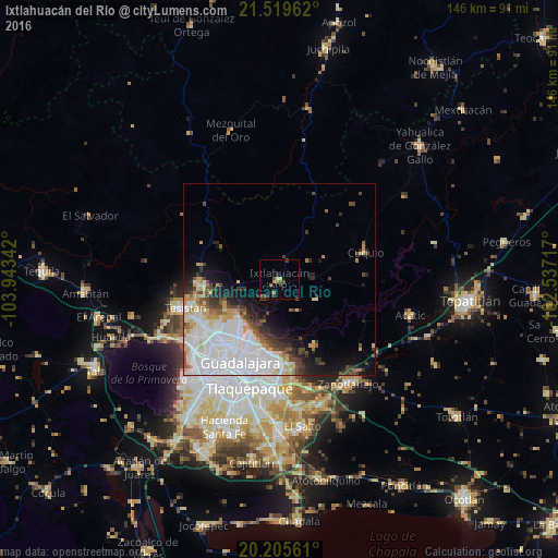
Analysis of Ixtlahuacán del Río night lights 2016
Square area 10x10 km:
 0%
0%90-99
0.4%80-89
1.98%70-79
0.99%60-69
1.39%50-59
0.79%40-49
3.97%30-39
1.19%20-29
1.59%10-19
0.79%0-9
86.9%Square area 50x50 km:
8.44%90-99
3.6%80-89
1.96%70-79
1.85%60-69
1.14%50-59
1.48%40-49
2.36%30-39
1.77%20-29
2.62%10-19
5.04%0-9
69.74%Clear (daylight) street map image can be seen on geolist.org.
Map coordinates:
21° 31' 10.6" North, 103° 56' 36.3" West
20° 51' 50.6" North, 103° 14' 25" West
20° 12' 20.2" North, 102° 32' 13.8" West
Some cities around Ixtlahuacán del Río sort by population:
• Guadalajara
27 km =16.8 mi,  215°
215°
• Zapopan
21.7 km =13.5 mi, 223°
• Tlaquepaque
25.4 km =15.8 mi,  192°
192°
• Tonalá
26.6 km =16.5 mi,  178°
178°
• Tesistán
24.9 km =15.5 mi,  253°
253°
• Zapotlanejo
32.3 km =20.1 mi,  146°
146°
• Coyula
22.9 km =14.2 mi, 176°
• Nuevo México
24.2 km =15 mi,  240°
240°
4004274 (p: 6,198)
Sources (retrieved 2019-11-25):
» Earth at Night: Flat Maps 2012, 2016