Nochistlán de Mejía night lights from space
Night Light of Nochistlán de Mejía (Zacatecas) from space (Mexico) Src. Average luminocity for 10x10km area is 11.7235% and for 50x50km: 1.7822%.
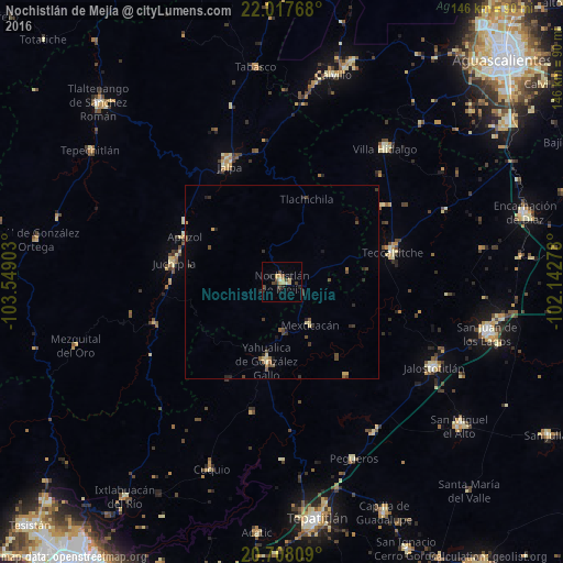
Analysis of Nochistlán de Mejía night lights 2016
Square area 10x10 km:
 0%
0%90-99
0.76%80-89
3.22%70-79
2.84%60-69
0%50-59
1.14%40-49
3.98%30-39
1.7%20-29
3.6%10-19
0.95%0-9
81.82%Square area 50x50 km:
0%90-99
0.06%80-89
0.35%70-79
0.26%60-69
0.14%50-59
0.26%40-49
0.66%30-39
0.42%20-29
0.51%10-19
0.34%0-9
97.01%Clear (daylight) street map image can be seen on geolist.org.
Map coordinates:
22° 1' 3.6" North, 103° 32' 56.5" West
21° 21' 51.7" North, 102° 50' 45.2" West
20° 42' 29.1" North, 102° 8' 34" West
Some cities around Nochistlán de Mejía sort by population:
• San Juan de los Lagos
54.9 km =34.1 mi,  103°
103°
• Jalostotitlán
45.2 km =28.1 mi,  118°
118°
• Teocaltiche
29.2 km =18.1 mi,  74°
74°
• Calvillo
55.1 km =34.2 mi,  13°
13°
• Villa Hidalgo
43.7 km =27.2 mi,  37°
37°
• Jalpa
33 km =20.5 mi,  335°
335°
• Yahualica de González Gallo
20.9 km =13 mi,  191°
191°
• Juchipila
28.5 km =17.7 mi,  279°
279°
3994912 (p: 16,562)
Sources (retrieved 2019-11-25):
» Earth at Night: Flat Maps 2012, 2016