Capilla de Guadalupe night lights from space
Night Light of Capilla de Guadalupe (Jalisco) from space (Mexico) Src. Average luminocity for 10x10km area is 13.2758% and for 50x50km: 7.0143%.
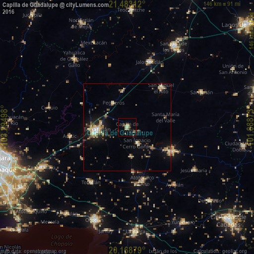
Analysis of Capilla de Guadalupe night lights 2016
Square area 10x10 km:
 0.4%
0.4%90-99
1.19%80-89
1.59%70-79
2.38%60-69
3.57%50-59
2.78%40-49
2.58%30-39
0.99%20-29
0.79%10-19
1.79%0-9
81.94%Square area 50x50 km:
0.3%90-99
0.72%80-89
1.35%70-79
1.18%60-69
0.77%50-59
0.7%40-49
1.46%30-39
0.99%20-29
1.5%10-19
4.19%0-9
86.84%Clear (daylight) street map image can be seen on geolist.org.
Map coordinates:
21° 28' 59.2" North, 103° 17' 41.9" West
20° 49' 38.6" North, 102° 35' 30.7" West
20° 10' 7.6" North, 101° 53' 19.4" West
Some cities around Capilla de Guadalupe sort by population:
• Tepatitlán de Morelos
17.9 km =11.1 mi,  266°
266°
• Arandas
28.9 km =18 mi,  118°
118°
• Atotonilco el Alto
31.9 km =19.8 mi,  164°
164°
• San Miguel el Alto
29.8 km =18.5 mi,  40°
40°
• Acatic
33.5 km =20.8 mi,  260°
260°
• San Ignacio Cerro Gordo
10.9 km =6.8 mi,  146°
146°
• San Francisco de Asís
25.8 km =16 mi,  173°
173°
• San José de Gracia
17.1 km =10.6 mi, 172°
4015546 (p: 13,308)
Sources (retrieved 2019-11-25):
» Earth at Night: Flat Maps 2012, 2016