Santa Rosa Treinta night lights from space
Night Light of Santa Rosa Treinta (Morelos) from space (Mexico) Src. Average luminocity for 10x10km area is 45.1715% and for 50x50km: 27.5465%.
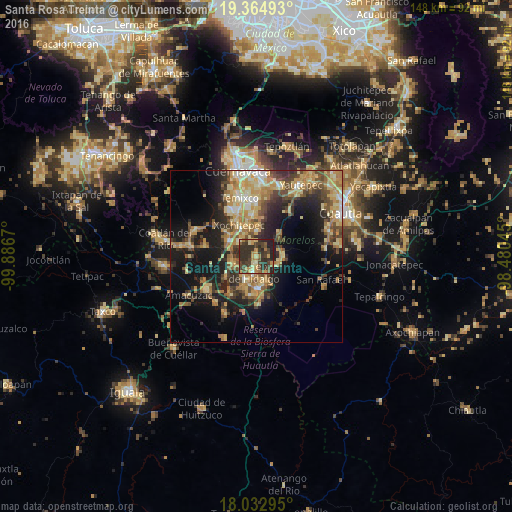
Analysis of Santa Rosa Treinta night lights 2016
Square area 10x10 km:
 0.21%
0.21%90-99
2.07%80-89
6.82%70-79
11.57%60-69
6.61%50-59
5.37%40-49
15.5%30-39
22.11%20-29
25%10-19
4.75%0-9
0%Square area 50x50 km:
1.16%90-99
2.66%80-89
6.1%70-79
5.6%60-69
5.51%50-59
3.35%40-49
5.82%30-39
4.65%20-29
7.5%10-19
15.18%0-9
42.47%Clear (daylight) street map image can be seen on geolist.org.
Map coordinates:
19° 21' 53.7" North, 99° 53' 12.1" West
18° 42' 0.9" North, 99° 11' 0.9" West
18° 1' 58.6" North, 98° 28' 49.6" West
Some cities around Santa Rosa Treinta sort by population:
• Zacatepec
5.2 km =3.2 mi,  187°
187°
• Xoxocotla
6.8 km =4.2 mi,  254°
254°
• Jojutla
9.5 km =5.9 mi,  177°
177°
• Tlaquiltenango
7.6 km =4.7 mi,  163°
163°
• Galeana
7.5 km =4.7 mi,  203°
203°
• Tlaltizapán
7 km =4.3 mi,  102°
102°
• Alpuyeca
9.1 km =5.7 mi,  299°
299°
• Chiconcuac
9.5 km =5.9 mi,  344°
344°
3515163 (p: 16,691)
Sources (retrieved 2019-11-25):
» Earth at Night: Flat Maps 2012, 2016