Tres de Mayo night lights from space
Night Light of Tres de Mayo (Morelos) from space (Mexico) Src. Average luminocity for 10x10km area is 84.4351% and for 50x50km: 29.2715%.
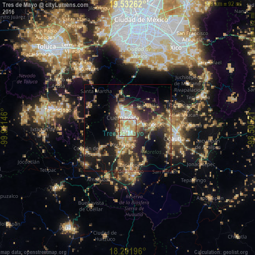
Analysis of Tres de Mayo night lights 2016
Square area 10x10 km:
 11.04%
90-99
27.27%80-89
30.3%70-79
19.91%60-69
8.01%50-59
3.03%40-49
0.43%30-39
0%20-29
0%10-19
0%0-9
0%Square area 50x50 km:
1.34%90-99
3.12%80-89
6.3%70-79
5.62%60-69
5.08%50-59
3.38%40-49
6.53%30-39
4.83%20-29
9.3%10-19
16.46%0-9
38.05%Clear (daylight) street map image can be seen on geolist.org.
Map coordinates:
19° 31' 57.4" North, 99° 54' 41.3" West
18° 52' 7" North, 99° 12' 30" West
18° 12' 7.1" North, 98° 30' 18.8" West
Some cities around Tres de Mayo sort by population:
• Cuernavaca
6.8 km =4.2 mi,  339°
339°
• Jiutepec
3.5 km =2.2 mi,  66°
66°
• Temixco
2.5 km =1.6 mi,  225°
225°
• Emiliano Zapata
4 km =2.5 mi,  141°
141°
• Progreso
6 km =3.7 mi,  77°
77°
• Unidad Habitacional José María Morelos y Pavón
7.8 km =4.8 mi, 226°
• Independencia
9.1 km =5.7 mi, 83°
• Calera Chica
3 km =1.9 mi,  112°
112°
8858112 (p: 17,966)
Sources (retrieved 2019-11-25):
» Earth at Night: Flat Maps 2012, 2016