Santiago Juxtlahuaca night lights from space
Night Light of Santiago Juxtlahuaca (Oaxaca) from space (Mexico) Src. Average luminocity for 10x10km area is 5.6281% and for 50x50km: 0.566%.
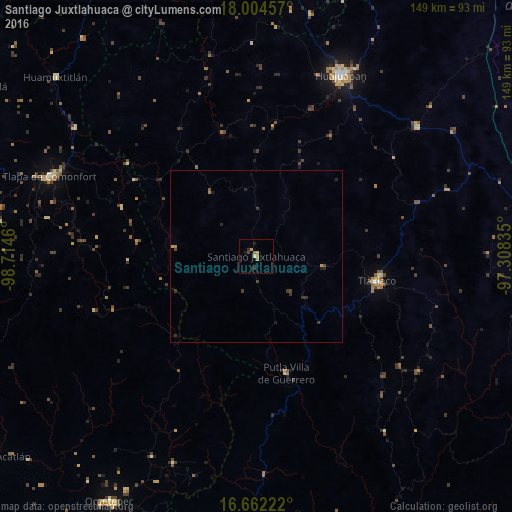
Analysis of Santiago Juxtlahuaca night lights 2016
Square area 10x10 km:
 0%
0%90-99
0%80-89
0.83%70-79
1.65%60-69
1.86%50-59
0.62%40-49
1.45%30-39
0.41%20-29
1.45%10-19
1.65%0-9
90.08%Square area 50x50 km:
0%90-99
0%80-89
0.03%70-79
0.13%60-69
0.14%50-59
0.05%40-49
0.17%30-39
0.29%20-29
0.19%10-19
0.19%0-9
98.8%Clear (daylight) street map image can be seen on geolist.org.
Map coordinates:
18° 0' 16.5" North, 98° 42' 52.6" West
17° 20' 4.6" North, 98° 0' 41.3" West
16° 39' 44" North, 97° 18' 30.1" West
Some cities around Santiago Juxtlahuaca sort by population:
• Ciudad de Huajuapan de León
58.1 km =36.1 mi,  25°
25°
• Tlapa de Comonfort
64.3 km =40 mi,  291°
291°
• Ometepec
83.1 km =51.6 mi,  210°
210°
• Heroica Ciudad de Tlaxiaco
35.9 km =22.3 mi,  101°
101°
• Asunción Nochixtlán
84.5 km =52.5 mi,  80°
80°
• Putla Villa de Guerrero
35.4 km =22 mi,  165°
165°
• Huamuxtitlán
78.5 km =48.8 mi,  311°
311°
• Tamazulapam Villa del Progreso
60.1 km =37.3 mi,  50°
50°
3516945 (p: 9,565)
Sources (retrieved 2019-11-25):
» Earth at Night: Flat Maps 2012, 2016