Putla Villa de Guerrero night lights from space
Night Light of Putla Villa de Guerrero (Oaxaca) from space (Mexico) Src. Average luminocity for 10x10km area is 3.5952% and for 50x50km: 0.2982%.
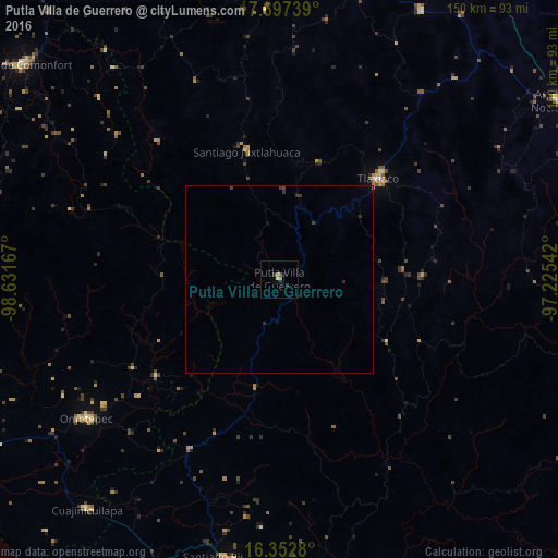
Analysis of Putla Villa de Guerrero night lights 2016
Square area 10x10 km:
 0%
0%90-99
0%80-89
0.87%70-79
0%60-69
1.73%50-59
0.87%40-49
0%30-39
0.87%20-29
1.73%10-19
0.87%0-9
93.07%Square area 50x50 km:
0%90-99
0%80-89
0.03%70-79
0%60-69
0.08%50-59
0.04%40-49
0.03%30-39
0.23%20-29
0.16%10-19
0.06%0-9
99.36%Clear (daylight) street map image can be seen on geolist.org.
Map coordinates:
17° 41' 50.6" North, 98° 37' 54" West
17° 1' 34.7" North, 97° 55' 42.7" West
16° 21' 10.1" North, 97° 13' 31.5" West
Some cities around Putla Villa de Guerrero sort by population:
• Pinotepa Nacional
77.4 km =48.1 mi,  189°
189°
• Ometepec
63.2 km =39.3 mi,  233°
233°
• Heroica Ciudad de Tlaxiaco
37.7 km =23.4 mi,  44°
44°
• Cuajinicuilapa
80.3 km =49.9 mi,  220°
220°
• Santiago Juxtlahuaca
35.4 km =22 mi,  345°
345°
• Pinotepa de Don Luis
66.8 km =41.5 mi,  184°
184°
• San Juan Colorado
63 km =39.1 mi, 182°
• Tamazulapam Villa del Progreso
81.6 km =50.7 mi,  27°
27°
3520935 (p: 10,925)
Sources (retrieved 2019-11-25):
» Earth at Night: Flat Maps 2012, 2016