Santiago Cuautlalpan night lights from space
Night Light of Santiago Cuautlalpan (México) from space (Mexico) Src. Average luminocity for 10x10km area is 67.1756% and for 50x50km: 54.1003%.
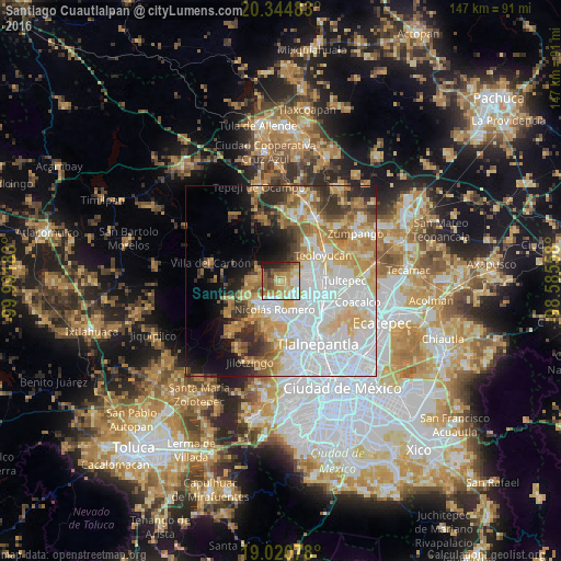
Analysis of Santiago Cuautlalpan night lights 2016
Square area 10x10 km:
 8.06%
8.06%90-99
12.81%80-89
16.94%70-79
15.7%60-69
9.5%50-59
13.02%40-49
7.44%30-39
5.37%20-29
7.64%10-19
3.51%0-9
0%Square area 50x50 km:
19.4%90-99
9.1%80-89
8.52%70-79
7.63%60-69
6.7%50-59
4.46%40-49
3.86%30-39
4.58%20-29
5.46%10-19
7.07%0-9
23.21%Clear (daylight) street map image can be seen on geolist.org.
Map coordinates:
20° 20' 41.4" North, 99° 59' 30.6" West
19° 41' 3" North, 99° 17' 19.3" West
19° 1' 14.8" North, 98° 35' 8.1" West
Some cities around Santiago Cuautlalpan sort by population:
• Cuautitlán Izcalli
8.8 km =5.5 mi,  120°
120°
• Nicolás Romero
5.1 km =3.2 mi,  201°
201°
• Tepotzotlán
7.9 km =4.9 mi,  58°
58°
• Huilango
3.4 km =2.1 mi,  96°
96°
• Veintidós de Febrero
10.1 km =6.3 mi,  216°
216°
• Progreso Industrial
8.9 km =5.5 mi,  233°
233°
• San Mateo Xoloc
4.9 km =3 mi, 59°
• Santa Gertrudis
9.8 km =6.1 mi,  303°
303°
3529983 (p: 9,786)
Sources (retrieved 2019-11-25):
» Earth at Night: Flat Maps 2012, 2016