Veintidós de Febrero night lights from space
Night Light of Veintidós de Febrero (México) from space (Mexico) Src. Average luminocity for 10x10km area is 73.8574% and for 50x50km: 52.3527%.
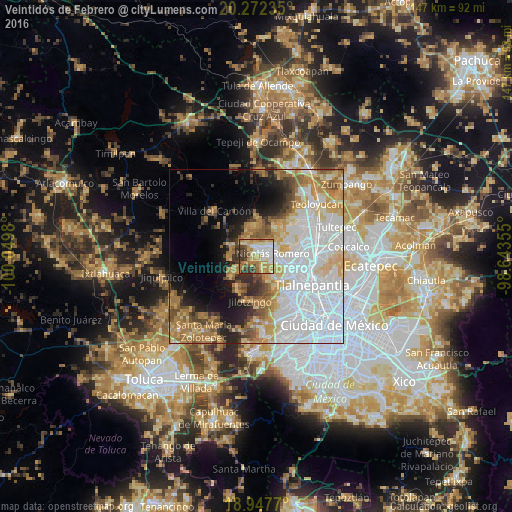
Analysis of Veintidós de Febrero night lights 2016
Square area 10x10 km:
 14.26%
90-99
12.81%80-89
16.94%70-79
19.83%60-69
13.64%50-59
3.93%40-49
8.26%30-39
9.3%20-29
1.03%10-19
0%0-9
0%Square area 50x50 km:
20.4%90-99
8.18%80-89
7.04%70-79
6.97%60-69
7.42%50-59
4.39%40-49
3.92%30-39
3.08%20-29
4.95%10-19
7.33%0-9
26.32%Clear (daylight) street map image can be seen on geolist.org.
Map coordinates:
20° 16' 20.5" North, 100° 2' 59.3" West
19° 36' 41" North, 99° 20' 48" West
18° 56' 51.7" North, 98° 38' 36.8" West
Some cities around Veintidós de Febrero sort by population:
• Ciudad López Mateos
11.1 km =6.9 mi,  122°
122°
• Nicolás Romero
5.4 km =3.4 mi,  51°
51°
• Huilango
12.2 km =7.6 mi, 50°
• Progreso Industrial
3 km =1.9 mi,  338°
338°
• Santiago Cuautlalpan
10.1 km =6.3 mi,  36°
36°
• Quinto Barrio (Ejido Cahuacán)
7.6 km =4.7 mi,  279°
279°
• Santa María Magdalena Cahuacán
7.6 km =4.7 mi,  292°
292°
• San José el Vidrio
6.1 km =3.8 mi,  319°
319°
8858134 (p: 13,021)
Sources (retrieved 2019-11-25):
» Earth at Night: Flat Maps 2012, 2016