Progreso Industrial night lights from space
Night Light of Progreso Industrial (México) from space (Mexico) Src. Average luminocity for 10x10km area is 68.4091% and for 50x50km: 48.8462%.
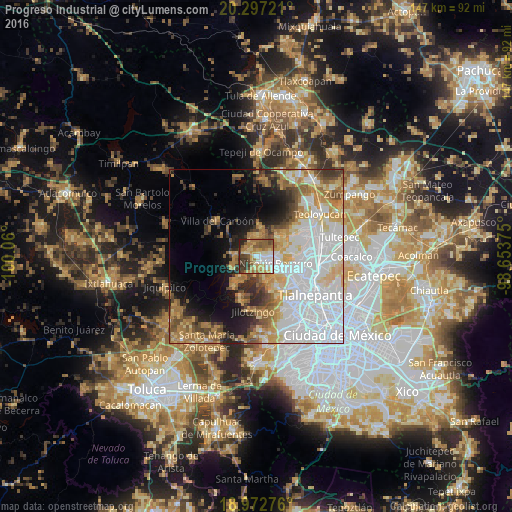
Analysis of Progreso Industrial night lights 2016
Square area 10x10 km:
 10.74%
90-99
10.12%80-89
15.08%70-79
13.02%60-69
15.7%50-59
12.19%40-49
10.33%30-39
7.64%20-29
4.96%10-19
0.21%0-9
0%Square area 50x50 km:
17.8%90-99
7.89%80-89
6.68%70-79
6.36%60-69
6.91%50-59
4.52%40-49
4.2%30-39
3.78%20-29
4.66%10-19
7.73%0-9
29.46%Clear (daylight) street map image can be seen on geolist.org.
Map coordinates:
20° 17' 50" North, 100° 3' 36" West
19° 38' 10.9" North, 99° 21' 24.7" West
18° 58' 21.9" North, 98° 39' 13.5" West
Some cities around Progreso Industrial sort by population:
• Nicolás Romero
5.3 km =3.3 mi,  83°
83°
• Huilango
11.6 km =7.2 mi,  64°
64°
• Veintidós de Febrero
3 km =1.9 mi,  158°
158°
• Santiago Cuautlalpan
8.9 km =5.5 mi,  53°
53°
• Quinto Barrio (Ejido Cahuacán)
6.6 km =4.1 mi,  256°
256°
• Santa María Magdalena Cahuacán
5.9 km =3.7 mi,  271°
271°
• San José el Vidrio
3.4 km =2.1 mi,  303°
303°
• Santa Gertrudis
10.8 km =6.7 mi,  354°
354°
3521111 (p: 11,289)
Sources (retrieved 2019-11-25):
» Earth at Night: Flat Maps 2012, 2016