Santa Gertrudis night lights from space
Night Light of Santa Gertrudis (México) from space (Mexico) Src. Average luminocity for 10x10km area is 16.6157% and for 50x50km: 39.3764%.
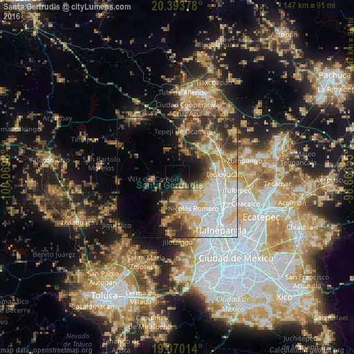
Analysis of Santa Gertrudis night lights 2016
Square area 10x10 km:
 0%
0%90-99
0%80-89
2.27%70-79
2.48%60-69
5.99%50-59
1.86%40-49
2.48%30-39
2.27%20-29
4.34%10-19
22.52%0-9
55.79%Square area 50x50 km:
10.49%90-99
6.4%80-89
5.89%70-79
5.6%60-69
5.6%50-59
4.17%40-49
4.87%30-39
5.37%20-29
6.77%10-19
7.61%0-9
37.23%Clear (daylight) street map image can be seen on geolist.org.
Map coordinates:
20° 23' 37.6" North, 100° 4' 11.3" West
19° 43' 60" North, 99° 22' 0" West
19° 4' 12.5" North, 98° 39' 48.8" West
Some cities around Santa Gertrudis sort by population:
• Nicolás Romero
12 km =7.5 mi,  148°
148°
• Huilango
12.9 km =8 mi,  116°
116°
• Progreso Industrial
10.8 km =6.7 mi,  174°
174°
• Santiago Cuautlalpan
9.8 km =6.1 mi, 123°
• San Mateo Xoloc
12.8 km =8 mi,  103°
103°
• Villa del Carbón
10.2 km =6.3 mi,  267°
267°
• Quinto Barrio (Ejido Cahuacán)
13.5 km =8.4 mi,  203°
203°
• San José el Vidrio
9.1 km =5.7 mi,  191°
191°
3517449 (p: 5,185)
Sources (retrieved 2019-11-25):
» Earth at Night: Flat Maps 2012, 2016