Santa María Zolotepec night lights from space
Night Light of Santa María Zolotepec (México) from space (Mexico) Src. Average luminocity for 10x10km area is 60.7624% and for 50x50km: 50.9016%.
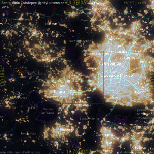
Analysis of Santa María Zolotepec night lights 2016
Square area 10x10 km:
 0.41%
0.41%90-99
0.62%80-89
8.47%70-79
15.91%60-69
35.33%50-59
13.22%40-49
16.32%30-39
8.06%20-29
1.65%10-19
0%0-9
0%Square area 50x50 km:
8.58%90-99
6.84%80-89
8.39%70-79
10.4%60-69
12.02%50-59
6.57%40-49
7.21%30-39
5.62%20-29
9.03%10-19
12.26%0-9
13.08%Clear (daylight) street map image can be seen on geolist.org.
Map coordinates:
20° 4' 44.6" North, 100° 11' 47" West
19° 25' 2.2" North, 99° 29' 35.8" West
18° 45' 10.1" North, 98° 47' 24.5" West
Some cities around Santa María Zolotepec sort by population:
• Xonacatlán
3.9 km =2.4 mi,  249°
249°
• Villa Cuauhtémoc
6.9 km =4.3 mi,  269°
269°
• San Pedro Arriba
10.6 km =6.6 mi,  316°
316°
• San Nicolás Tolentino
10.5 km =6.5 mi,  231°
231°
• La Constitución Toltepec
9.6 km =6 mi,  217°
217°
• San Lorenzo Oyamel
9 km =5.6 mi,  281°
281°
• San Pedro Abajo
10.5 km =6.5 mi,  312°
312°
• San Mateo Atarasquíllo
11 km =6.8 mi,  162°
162°
3514013 (p: 10,656)
Sources (retrieved 2019-11-25):
» Earth at Night: Flat Maps 2012, 2016