San Pedro Arriba night lights from space
Night Light of San Pedro Arriba (México) from space (Mexico) Src. Average luminocity for 10x10km area is 47.5021% and for 50x50km: 42.3196%.
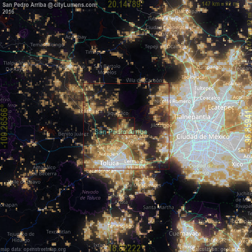
Analysis of San Pedro Arriba night lights 2016
Square area 10x10 km:
 0%
0%90-99
0.83%80-89
5.17%70-79
11.57%60-69
20.25%50-59
15.08%40-49
13.64%30-39
4.55%20-29
10.12%10-19
14.67%0-9
4.13%Square area 50x50 km:
4.3%90-99
4.05%80-89
6.36%70-79
7.99%60-69
12.61%50-59
6.59%40-49
8.09%30-39
6.54%20-29
10.25%10-19
14.88%0-9
18.33%Clear (daylight) street map image can be seen on geolist.org.
Map coordinates:
20° 8' 52.4" North, 100° 15' 56.4" West
19° 29' 11.1" North, 99° 33' 45.1" West
18° 49' 20" North, 98° 51' 33.9" West
Some cities around San Pedro Arriba sort by population:
• Xonacatlán
9.7 km =6 mi,  158°
158°
• Villa Cuauhtémoc
7.8 km =4.8 mi,  177°
177°
• Santa María Zolotepec
10.6 km =6.6 mi,  136°
136°
• San Nicolás Tolentino
14.2 km =8.8 mi, 183°
• Santa Ana Jilotzingo
8.5 km =5.3 mi,  113°
113°
• La Constitución Toltepec
15.4 km =9.6 mi,  174°
174°
• San Lorenzo Oyamel
6.1 km =3.8 mi,  195°
195°
• Jicaltepec Autopan
15.2 km =9.4 mi,  212°
212°
3518020 (p: 7,040)
Sources (retrieved 2019-11-25):
» Earth at Night: Flat Maps 2012, 2016