San Lorenzo Oyamel night lights from space
Night Light of San Lorenzo Oyamel (Morelos) from space (Mexico) Src. Average luminocity for 10x10km area is 66.2087% and for 50x50km: 44.7651%.
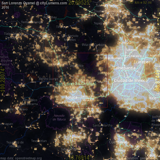
Analysis of San Lorenzo Oyamel night lights 2016
Square area 10x10 km:
 0.62%
0.62%90-99
2.07%80-89
10.54%70-79
16.94%60-69
46.49%50-59
13.84%40-49
9.5%30-39
0%20-29
0%10-19
0%0-9
0%Square area 50x50 km:
4.44%90-99
4.4%80-89
7.13%70-79
9.04%60-69
13.2%50-59
6.64%40-49
8.24%30-39
6.7%20-29
10.75%10-19
14.64%0-9
14.83%Clear (daylight) street map image can be seen on geolist.org.
Map coordinates:
20° 5' 42.9" North, 100° 16' 50.7" West
19° 26' 0.8" North, 99° 34' 39.4" West
18° 46' 8.9" North, 98° 52' 28.2" West
Some cities around San Lorenzo Oyamel sort by population:
• Xonacatlán
6.1 km =3.8 mi,  121°
121°
• San Andrés Cuexcontitlán
9.5 km =5.9 mi,  209°
209°
• Villa Cuauhtémoc
2.7 km =1.7 mi,  133°
133°
• Santa María Zolotepec
9 km =5.6 mi,  101°
101°
• San Pedro Arriba
6.1 km =3.8 mi,  15°
15°
• San Nicolás Tolentino
8.3 km =5.2 mi,  175°
175°
• San Pedro Abajo
5.4 km =3.4 mi,  11°
11°
• Jicaltepec Autopan
9.6 km =6 mi,  223°
223°
3518538 (p: 5,753)
Sources (retrieved 2019-11-25):
» Earth at Night: Flat Maps 2012, 2016