San Pedro Abajo night lights from space
Night Light of San Pedro Abajo (México) from space (Mexico) Src. Average luminocity for 10x10km area is 50.626% and for 50x50km: 42.4065%.
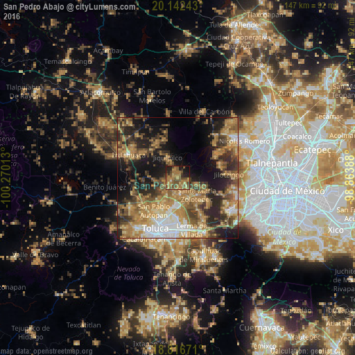
Analysis of San Pedro Abajo night lights 2016
Square area 10x10 km:
 0%
0%90-99
0.83%80-89
6.2%70-79
12.19%60-69
23.97%50-59
16.53%40-49
11.98%30-39
3.93%20-29
10.12%10-19
12.19%0-9
2.07%Square area 50x50 km:
4.34%90-99
4.09%80-89
6.38%70-79
7.98%60-69
12.66%50-59
6.48%40-49
8.1%30-39
6.52%20-29
10.36%10-19
14.88%0-9
18.21%Clear (daylight) street map image can be seen on geolist.org.
Map coordinates:
20° 8' 32.7" North, 100° 16' 12.5" West
19° 28' 51.3" North, 99° 34' 1.2" West
18° 49' 0.2" North, 98° 51' 50" West
Some cities around San Pedro Abajo sort by population:
• Xonacatlán
9.4 km =5.8 mi,  154°
154°
• San Andrés Cuexcontitlán
14.7 km =9.1 mi,  202°
202°
• Villa Cuauhtémoc
7.2 km =4.5 mi,  173°
173°
• Santa María Zolotepec
10.5 km =6.5 mi,  132°
132°
• San Nicolás Tolentino
13.6 km =8.5 mi,  182°
182°
• Santa Ana Jilotzingo
8.7 km =5.4 mi,  108°
108°
• San Lorenzo Oyamel
5.4 km =3.4 mi,  191°
191°
• Jicaltepec Autopan
14.4 km =8.9 mi,  212°
212°
3827229 (p: 5,581)
Sources (retrieved 2019-11-25):
» Earth at Night: Flat Maps 2012, 2016