Villa Cuauhtémoc night lights from space
Night Light of Villa Cuauhtémoc (México) from space (Mexico) Src. Average luminocity for 10x10km area is 67.5434% and for 50x50km: 46.5649%.
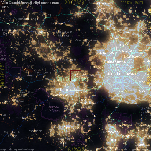
Analysis of Villa Cuauhtémoc night lights 2016
Square area 10x10 km:
 3.1%
3.1%90-99
2.89%80-89
11.78%70-79
18.39%60-69
40.29%50-59
15.29%40-49
6.2%30-39
1.45%20-29
0.62%10-19
0%0-9
0%Square area 50x50 km:
4.87%90-99
4.92%80-89
7.42%70-79
9.66%60-69
13.53%50-59
7.07%40-49
8.3%30-39
6.67%20-29
10.05%10-19
13.78%0-9
13.73%Clear (daylight) street map image can be seen on geolist.org.
Map coordinates:
20° 4' 42.7" North, 100° 15' 42.7" West
19° 25' 0.3" North, 99° 33' 31.4" West
18° 45' 8.2" North, 98° 51' 20.2" West
Some cities around Villa Cuauhtémoc sort by population:
• Xonacatlán
3.5 km =2.2 mi,  111°
111°
• Santa María Zolotepec
6.9 km =4.3 mi,  89°
89°
• San Pedro Arriba
7.8 km =4.8 mi,  357°
357°
• San Nicolás Tolentino
6.6 km =4.1 mi,  191°
191°
• Santa Ana Jilotzingo
8.6 km =5.3 mi,  59°
59°
• La Constitución Toltepec
7.6 km =4.7 mi,  172°
172°
• San Lorenzo Oyamel
2.7 km =1.7 mi,  313°
313°
• San Pedro Abajo
7.2 km =4.5 mi,  353°
353°
3514683 (p: 11,241)
Sources (retrieved 2019-11-25):
» Earth at Night: Flat Maps 2012, 2016