La Constitución Toltepec night lights from space
Night Light of La Constitución Toltepec (México) from space (Mexico) Src. Average luminocity for 10x10km area is 73.1921% and for 50x50km: 46.8838%.
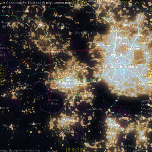
Analysis of La Constitución Toltepec night lights 2016
Square area 10x10 km:
 13.64%
90-99
15.91%80-89
7.02%70-79
18.6%60-69
18.6%50-59
14.26%40-49
6.4%30-39
5.58%20-29
0%10-19
0%0-9
0%Square area 50x50 km:
4.84%90-99
4.96%80-89
8.07%70-79
9.97%60-69
13.21%50-59
7.02%40-49
8.06%30-39
6.24%20-29
10.64%10-19
12.91%0-9
14.09%Clear (daylight) street map image can be seen on geolist.org.
Map coordinates:
20° 0' 38.4" North, 100° 15' 8.3" West
19° 20' 55" North, 99° 32' 57" West
18° 41' 1.9" North, 98° 50' 45.8" West
Some cities around La Constitución Toltepec sort by population:
• San José Guadalupe Otzacatipan
4.5 km =2.8 mi,  264°
264°
• San Mateo Otzacatipan
6 km =3.7 mi,  252°
252°
• San Pedro Totoltepec
4.8 km =3 mi,  209°
209°
• Xonacatlán
6.7 km =4.2 mi,  19°
19°
• Santa María Totoltepec
6.5 km =4 mi,  224°
224°
• El Cerrillo Vista Hermosa
2.9 km =1.8 mi,  165°
165°
• San Nicolás Tolentino
2.6 km =1.6 mi,  295°
295°
• San Miguel Totoltepec
4.1 km =2.5 mi,  227°
227°
8858218 (p: 6,402)
Sources (retrieved 2019-11-25):
» Earth at Night: Flat Maps 2012, 2016