Santa Ana Pacueco night lights from space
Night Light of Santa Ana Pacueco (Guanajuato) from space (Mexico) Src. Average luminocity for 10x10km area is 55.9659% and for 50x50km: 8.2809%.
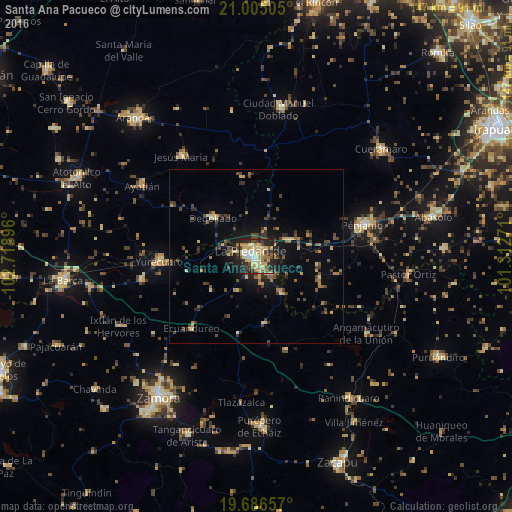
Analysis of Santa Ana Pacueco night lights 2016
Square area 10x10 km:
 4.55%
4.55%90-99
9.66%80-89
17.05%70-79
10.42%60-69
6.82%50-59
2.65%40-49
11.17%30-39
9.28%20-29
21.02%10-19
7.39%0-9
0%Square area 50x50 km:
0.19%90-99
0.53%80-89
1.62%70-79
1.06%60-69
1.16%50-59
0.76%40-49
2.59%30-39
1.55%20-29
2.38%10-19
4.92%0-9
83.25%Clear (daylight) street map image can be seen on geolist.org.
Map coordinates:
21° 0' 18.2" North, 102° 43' 8.3" West
20° 20' 50" North, 102° 0' 57" West
19° 41' 11.7" North, 101° 18' 45.8" West
Some cities around Santa Ana Pacueco sort by population:
• La Piedad
1.6 km =1 mi,  250°
250°
• Pénjamo
32 km =19.9 mi,  73°
73°
• Yurécuaro
28 km =17.4 mi,  267°
267°
• Ayotlán
38.1 km =23.7 mi,  302°
302°
• Degollado
19.3 km =12 mi,  313°
313°
• Tanhuato de Guerrero
33.6 km =20.9 mi,  258°
258°
• Jesús María
35.9 km =22.3 mi,  323°
323°
• La Ribera
27.8 km =17.3 mi, 270°
3984690 (p: 10,052)
Sources (retrieved 2019-11-25):
» Earth at Night: Flat Maps 2012, 2016