Ayotlán night lights from space
Night Light of Ayotlán (Jalisco) from space (Mexico) Src. Average luminocity for 10x10km area is 8.6742% and for 50x50km: 8.0295%.
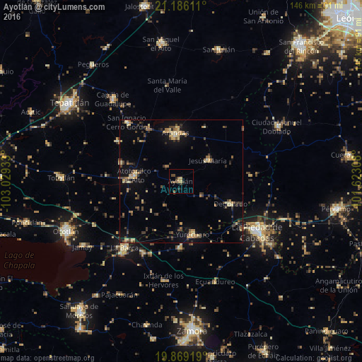
Analysis of Ayotlán night lights 2016
Square area 10x10 km:
 0%
0%90-99
0%80-89
0.76%70-79
0.76%60-69
3.41%50-59
1.89%40-49
3.41%30-39
1.52%20-29
1.52%10-19
0.76%0-9
85.98%Square area 50x50 km:
0.08%90-99
0.38%80-89
1.69%70-79
1.14%60-69
1.21%50-59
0.62%40-49
2.2%30-39
1.84%20-29
1.44%10-19
4.15%0-9
85.25%Clear (daylight) street map image can be seen on geolist.org.
Map coordinates:
21° 11' 10" North, 103° 1' 45.6" West
20° 31' 44.7" North, 102° 19' 34.3" West
19° 52' 9.1" North, 101° 37' 23.1" West
Some cities around Ayotlán sort by population:
• Arandas
19.7 km =12.2 mi,  353°
353°
• Atotonilco el Alto
19.2 km =11.9 mi,  277°
277°
• Yurécuaro
21.9 km =13.6 mi,  168°
168°
• Degollado
19.6 km =12.2 mi,  110°
110°
• Tanhuato de Guerrero
27.1 km =16.8 mi,  181°
181°
• Jesús María
13.8 km =8.6 mi,  51°
51°
• La Ribera
20.5 km =12.7 mi, 167°
• San Francisco de Asís
25.8 km =16 mi,  286°
286°
4017936 (p: 11,724)
Sources (retrieved 2019-11-25):
» Earth at Night: Flat Maps 2012, 2016